Florida's Rainy Season Ends With Drought Still Lingering Despite October Downpours and November Flooding
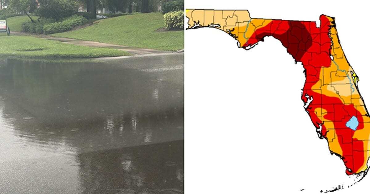
Florida's 2026 rainy season is over on the calendar, but it did not end the drought that began in the fall of 2025. A season of patchy summer storms, a burst of very heavy October rain in some cities and record-setting flooding along the Space Coast in early November have left the state going into the dry season with very different conditions from one region to the next. Federal drought maps now show most short-term drought gone from the peninsula. Long-term dryness remains near Bradenton, around Fort Myers and in parts of the Everglades, and water managers are keeping strict watering limits in place for millions of residents.
The uneven picture was laid out in a Nov. 5 analysis by Irene Sans of the Florida Public Radio Emergency Network (FPREN), published by WFSU and other public radio stations. It drew on rainfall records kept by National Weather Service offices across the state. As of Sept. 29, about 52% of Florida was in some level of drought, according to that analysis, and statewide September rainfall came in at about 82% of normal. North Florida got only about 58% of its normal September rain.
A summer that came up short
In most of Florida's big cities, rain from June through September, the core of the rainy season, came in well below average. Afternoon thunderstorms often formed without delivering much. In Orlando, the weather service in Melbourne counted thunderstorms on 21 days in September, but measurable rain fell on only 14 of them. Orlando International Airport recorded 2.57 inches for the month, against a normal of 6.37 inches.
The four-month totals compiled by the weather service offices show how far short several cities fell:
| City | June to Sept. 2026 rainfall | Average |
|---|---|---|
| Orlando | 19.39 inches | 29.57 inches |
| Tallahassee | 19.41 inches | 27.41 inches |
| Jacksonville | 25.16 inches | 28.81 inches |
| Melbourne | 25.75 inches | 28.63 inches |
| Tampa | 26.39 inches | 30.24 inches |
There were exceptions. Titusville finished its rainy season with 38.83 inches, well above its average of 29.4 inches. Gainesville's wettest month was August, when it got 11.35 inches.
South Florida had its own deficits. In a drought statement issued Oct. 29, the National Weather Service in Miami reported that Miami International Airport had recorded 31.50 inches since May 1. That was 19.63 inches below normal, or 62% of the usual amount, and ranked among the 12 driest wet seasons on record there so far. Naples was at 89% of normal. Fort Lauderdale-Hollywood International was slightly above normal, at 105%.
October brought relief to some cities, not all
October rain was very heavy in parts of the state and close to absent in others. In some cities it fell in a short burst early in the month and then stopped as cooler, drier air arrived.
| Location | Rainfall | Normal |
|---|---|---|
| Sarasota-Bradenton, October | 9.76 inches | 2.76 inches |
| Tampa, October | 5.47 inches | 2.34 inches |
| St. Petersburg, October | 4.99 inches | 2.16 inches |
| Fort Myers, October | 1.21 inches | 3.08 inches |
| Jacksonville, Oct. 1 to 14 | 11.23 inches | 2.61 inches |
| Tallahassee, Oct. 1 to 10 | 6.71 inches | 1.21 inches |
Sarasota-Bradenton had its fifth-wettest October on record, and Tampa its 11th-wettest. Fort Myers, by contrast, got well under half its normal October rain. Even where the rain was heavy, it did not make up for the year. Tallahassee was still 11.13 inches below normal for the year as of Oct. 10, and it then went without measurable rain through Oct. 27. Jacksonville's rain also fell off sharply in the second half of the month.
The weather service in Tampa Bay puts the typical end of the rainy season across most of West-Central Florida at about Oct. 10. The Melbourne office uses Oct. 15 as the median start of the dry season for Orlando and Daytona Beach. In North Florida the line is blurrier, and cold fronts take over as the main source of fall and winter rain.
Flooding on the Space Coast
The sharpest contrast came in early November. Starting Nov. 1, persistent easterly winds and an upper-level disturbance brought repeated rounds of torrential rain to Brevard County, according to the National Weather Service in Melbourne. Preliminary totals from the weather service's Weather Prediction Center reached 24.69 inches near Malabar, 22.75 inches near Grant-Valkaria, 22 inches near Palm Bay and 20.84 inches near Melbourne Beach. Melbourne International Airport recorded about 13.70 inches, nearly half its average June-to-September total in four days.
Some areas got rain at levels associated with a 1-in-100-year event. The heaviest rain had ended by Nov. 5, but the weather service warned that flooding along the St. Johns River could get worse as runoff moves through the basin. The Florida Press is covering the flood emergency and the river flooding in separate reports.
Where the drought stands now
The U.S. Drought Monitor map released Nov. 5, with data valid as of Nov. 3, made one- to two-category improvements across the Florida peninsula because of the recent heavy rain, according to the monitor's weekly summary as reported in search results. The summary said short-term drought has ended in Florida, leaving only lingering long-term drought.
Moderate drought remains near Bradenton and Fort Myers, where streamflows over the past 28 days were below the 20th percentile. Severe drought remains in parts of the Everglades, where weekly rainfall was lighter.
A week earlier, the Miami weather office's Oct. 29 statement had placed severe drought in the western Everglades of Miami-Dade County, extending into mainland Monroe County. Moderate drought covered eastern Collier County, the eastern Everglades, the western metro areas of Miami-Dade and the Lake Okeechobee region. That statement put Lake Okeechobee at 12.65 feet, 2.39 feet below its normal level for the date of 15.04 feet. No burn bans were in effect in South Florida.
Watering limits stay in place
Water managers have not relaxed restrictions. On Sept. 22, the Southwest Florida Water Management District's Governing Board extended its Modified Phase III "Extreme" Water Shortage order through March 31, 2027, with no changes to the rules, according to the district and Bay News 9. Residents in the district, including those on private wells, remain limited to watering once a week. The district cited a 12-month rainfall deficit of 15.4 inches through August. The board can ease or lift the order earlier if conditions improve.
Farther north and east, the St. Johns River Water Management District's Phase III Extreme Water Shortage order took effect May 11. It limits landscape irrigation to one day a week and bans it between 8 a.m. and 6 p.m. The order was still in effect in the district's most recent public updates. The district has said sustained, widespread above-average rain is needed to refill groundwater, restore river flows and make up the accumulated deficits. In August, the district reported 12-month rainfall deficits of 17.31 inches in Alachua County, 16.62 inches in Marion County and 11.39 inches in Lake County, according to WFTV.
A strong El Niño points to a wetter winter
The outlook for the coming months may help close the remaining gaps. NOAA's U.S. Winter Outlook, released Oct. 15, favors wetter-than-average conditions across the southern tier of the country, including Florida, with near-normal temperatures most likely for parts of the Southeast. NOAA said drought is forecast to improve or end in the Southeast by the end of January 2027. National Weather Service Director Ken Graham said a very strong El Niño will likely bring a southward and eastward shift to the jet stream.
In South Florida, the weather service's Miami office said this El Niño could match or exceed the 1997-1998 event as the strongest on record since 1950, WPTV reported. Forecasters there expect above-normal rain during the dry season. They also expect a higher risk of flooding and strong storms, including tornadoes, and below-normal wildfire activity. WPTV noted that the 1997-1998 El Niño winter brought Florida's deadliest tornado outbreak, in February 1998.
The Climate Prediction Center gives South Florida "likely above normal" rainfall, a 50% to 60% chance, for November 2026 through January 2027, according to the Miami office. The seasonal drought outlook calls for drought to be removed across South Florida by the end of January. The office added that continued heavy rain will still be needed to fully end it.
What's next
The Drought Monitor updates its map every Thursday, so the next look at Florida comes Nov. 12. NOAA's next monthly and seasonal outlooks are due Nov. 19. For now, the water management districts' once-a-week watering rules remain in force, and residents in the Southwest Florida district are under that order through at least the end of March unless the board acts sooner. A wet El Niño winter would help refill aquifers and Lake Okeechobee. Forecasters warn that the same pattern also raises the risk of the kind of flooding and severe storms Brevard County saw this month.
Spotted an issue with this article?
Have something to say about this story?
Write us a letterComments
No comments yet. Be the first to weigh in.
Related Coverage

Experts Warn Florida's State-Subsidized Septic Biofilters Might Not Work as Intended
2d ago

TECO's Manatee Viewing Center in Apollo Beach Opens 40th Season With Turtle Habitat, Permanent Ray Tank
4d ago
Pasco County Will Buy the 153-Acre Hopkins Property to Relieve Crowded Wesley Chapel District Park
5d ago
Florida Ranks Fourth in the Nation for Forest Loss, and Development Claimed Most of the Trees, Study Finds
6d ago