Florida's First Winterlike Cold Front Arrives Thursday, Bringing 40s From Tallahassee to Orlando, Wind Chills in the 30s and Rough Seas
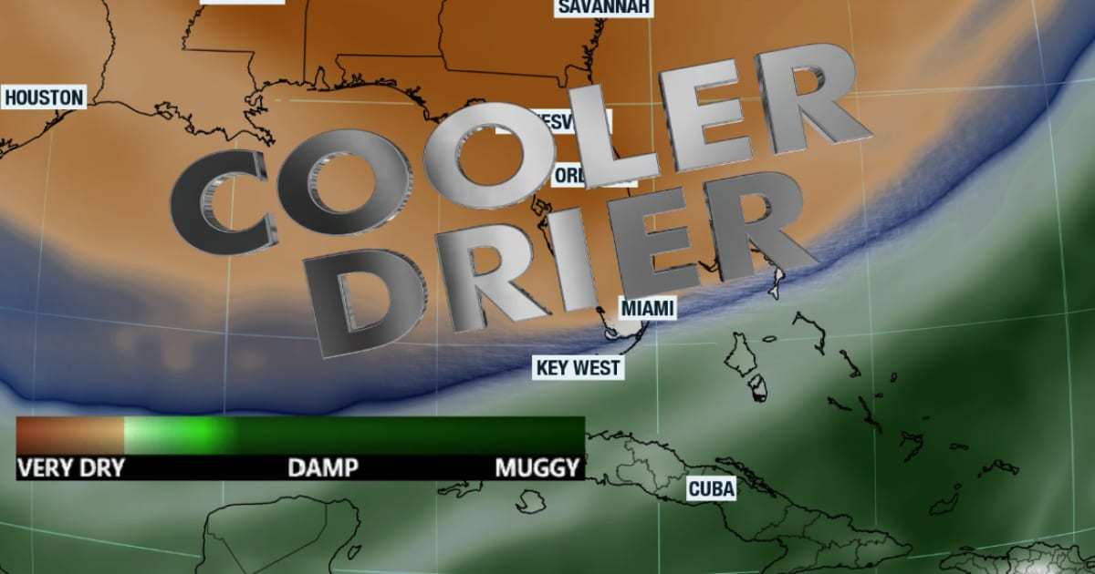
The coolest air of the fall is headed for Florida. A strong cold front is forecast to sweep down the peninsula Thursday and Thursday night, and by Saturday morning the National Weather Service expects lows in the low 40s in Tallahassee, the mid 40s in Jacksonville, the upper 40s in Orlando and Tampa, and near 60 degrees in Miami. Breezy northwest winds behind the front will make it feel colder still: forecasters in Jacksonville say wind chills could fall into the 30s Saturday morning for much of Northeast Florida, and the Melbourne office gives Greater Orlando a small chance of wind chills in the upper 30s.
The front also brings hazardous boating conditions on both coasts from Thursday into Saturday, a brief bump in fire weather concerns in parts of North and Central Florida, and dry air that should help flooded neighborhoods drain. It will not last long. Forecasters expect temperatures to rebound Sunday as winds turn onshore.
How the cold front sets up
The pattern change starts far from Florida. According to the weather service's Melbourne office, blocking over the high latitudes of North America will let the jet stream buckle late Wednesday, carving a deep trough over the eastern United States by Thursday. A storm forming over the Ohio Valley and moving toward the Delmarva Peninsula will drive the cold front south. The Melbourne office said the front should arrive in Central Florida late Thursday and clear its entire area by Friday morning, and that computer model ensembles are in excellent agreement through at least Saturday.
That office called it the most significant intrusion of continental air into the Florida peninsula so far this autumn, with moisture levels falling to 30 to 50 percent of normal. News4JAX meteorologist Chris Holtzman noted that the air behind the front originates in Canada.
Before the front, Florida stays warm. Highs in the low to mid 80s are forecast Tuesday and Wednesday, Veterans Day, across much of the state. A disturbance from the Gulf brings a 20 to 40 percent chance of showers and storms Wednesday afternoon in Central Florida, according to the Melbourne office, which said a couple of storms could turn strong with gusts up to 50 mph and coin-sized hail. The Miami office flagged the Lake Okeechobee region for an isolated strong storm Wednesday, and showers and isolated thunderstorms are possible in South Florida ahead of the front Thursday night. Widespread heavy rain is not expected anywhere.
Forecast lows across Florida
The table below shows the weather service's point forecasts, issued Tuesday morning, for seven Florida cities from Thursday night through Sunday.
| City | Thu night low | Fri high | Fri night low | Sat high | Sat night low | Sun high |
|---|---|---|---|---|---|---|
| Tallahassee | 49 | 64 | 41 | 61 | 40 | 65 |
| Pensacola | 49 | 66 | 43 | 62 | 46 | 65 |
| Jacksonville | 53 | 65 | 44 | 62 | 45 | 66 |
| Gainesville | 52 | 65 | 42 | 61 | 41 | 68 |
| Orlando | 59 | 69 | 47 | 65 | 47 | 72 |
| Tampa | 63 | 70 | 50 | 66 | 48 | 72 |
| Miami | 72 | 77 | 60 | 72 | 62 | 77 |
Forecasts are in degrees Fahrenheit and can shift as the front approaches. Inland and rural spots typically run colder than the city points listed.
North Florida and the Panhandle: first frost possible
North Florida gets the deepest chill. The weather service in Tallahassee expects highs in the upper 50s to mid 60s this weekend with lows in the mid 30s to low 40s, and it gives areas away from the coast a low to medium chance of frost over the weekend. Freezing temperatures are possible Saturday night only in the far northern counties of southeast Alabama and southwest Georgia, according to that office.
The Jacksonville office said a second, dry front sliding offshore Friday night will reinforce the cold air and keep winds up, driving wind chills into the 30s Saturday morning across much of its area. Saturday will likely be the coolest day there since mid-March. With calm winds and clear skies, lows Sunday morning could fall into the mid to upper 30s for inland locations north of Interstate 10, with the 40s elsewhere, and Sunday could bring the season's first inland frost to southeast Georgia and the Suwannee Valley.
The cold is right on schedule for Jacksonville. According to News4JAX, the city's average date for its first low at or below 40 degrees is Nov. 11, and the airport recorded 39 degrees on Nov. 10 last year. If Jacksonville International drops to 40 or below this weekend, it would be the first time since March. WLRN reported that Tallahassee last saw a low below 40 degrees on April 21.
Central Florida and Tampa Bay: 40s along I-4
In Central Florida, the weather service in Melbourne expects highs Friday in the upper 60s to low 70s and only the mid to upper 60s Saturday. Lows Friday and Saturday nights should reach the mid to upper 40s, except the low 50s along the coast from Cape Canaveral south. Wind chills near and northwest of Interstate 4 should reach 40 to 45 degrees, and the office puts the chance of wind chills in the upper 30s near and north of Greater Orlando at 15 to 20 percent, mainly Saturday morning, according to its Tuesday forecast discussion and WKMG News 6.
The Tampa Bay office said temperatures will run about 10 degrees below normal Friday and into the weekend, and inland parts of the Nature Coast could drop into the upper 30s Friday and Saturday nights. WLRN reported that Orlando and the Tampa Bay area last saw temperatures below 50 degrees on March 18.
South Florida: windows-open weather
South Florida's version of the cold snap is shorter and milder. The weather service in Miami said lows could fall into the 50s across most areas Friday night and again Saturday night, and highs Saturday may reach only the upper 60s north of Alligator Alley, with the low 70s farther south. The Miami point forecast calls for a low of 60 Friday night. WLRN reported that inland suburbs from Kendall north through Coral Springs could dip into the upper 50s, and that Miami last recorded a low of 60 or less on March 22. Lows return to the upper 60s early next week.
Rough seas and gusty winds
Boaters should plan around Friday and Saturday. The weather service in Melbourne expects fresh northwest winds of 15 to 25 knots early Friday and possibly again Friday night, with seas building to 3 to 4 feet near shore and up to 7 feet in the Gulf Stream, and said hazardous boating conditions return Friday through Saturday, especially offshore. The Jacksonville office said Small Craft Advisory conditions appear likely from Thursday afternoon through Saturday, and the Tallahassee office expects advisory-level northwest winds Thursday and Friday in the Gulf with gusts near 30 knots. The Miami office said hazardous marine conditions may develop on both its Atlantic and Gulf waters late in the week. Tampa Bay's waters should stay below cautionary levels, according to that office.
Before the front, a high risk of life-threatening rip currents continued Tuesday at Central Florida's Atlantic beaches, and the Melbourne office urged people to stay out of the ocean.
Fire weather and the flooded areas
The front will bring little rain to North Florida, and drier air plus stronger winds raise fire concerns there. WLRN reported that elevated fire danger could develop Thursday and Friday in parts of the state, with very low humidity and winds that could spread any fire quickly. The weather service offices are more measured: Jacksonville expects very good to high smoke dispersion Thursday and Friday as the front passes, Melbourne said fire weather thresholds should stay out of reach through Friday before humidity drops to 35 to 40 percent Saturday over the interior from Osceola County north, and Tampa Bay said it expects no fire weather hazards because humidity will stay well above critical levels. No fire weather watches or red flag warnings were in effect as of Tuesday.
For the parts of Florida still recovering from early November's record rain, the dry weather is welcome. The Melbourne office noted that extensive flooding continues along the St. Johns River after last week's exceptional rainfall in the upper basin, and it does not expect another significant rain chance until early next week. That office also said the cold snap should be brief: onshore winds return Sunday, highs climb back to the low to mid 70s in Central Florida, and 20 to 40 percent shower chances return by Monday or Tuesday.
What's next
Thursday is the transition day, with highs in the upper 70s to low 80s and a breezy westerly wind ahead of the front. The coldest mornings are Friday through Sunday, with Saturday the coldest for most of the state. Residents in North Florida should bring in tender plants and pets Saturday and Sunday nights, and anyone using a space heater for the first time this season should keep it clear of furniture and curtains. Forecasters expect near-normal temperatures to return early next week.
Spotted an issue with this article?
Have something to say about this story?
Write us a letterComments
No comments yet. Be the first to weigh in.
Related Coverage
St. Johns River Hits Major Flood Stage Near Cocoa as Seminole County Braces for Weeks of High Water and a Late-November Crest
3d ago
NOAA Retires the NAM, the Forecast Model Known for Overhyping Florida Hurricanes, in Favor of the Rapid Refresh Forecast System
4d ago

Florida Requests Federal Major Disaster Declaration for Fall Flooding as Martin County Counts 25 Homes Destroyed
Nov 3

Hurricane Center Gives Western Atlantic Low a 20% Chance as Florida Faces Rough Surf, Not a Storm
Nov 2