Soggy September: More Than 10 Inches of Rain Swamps Palm Beach County as Flood Risk Lingers
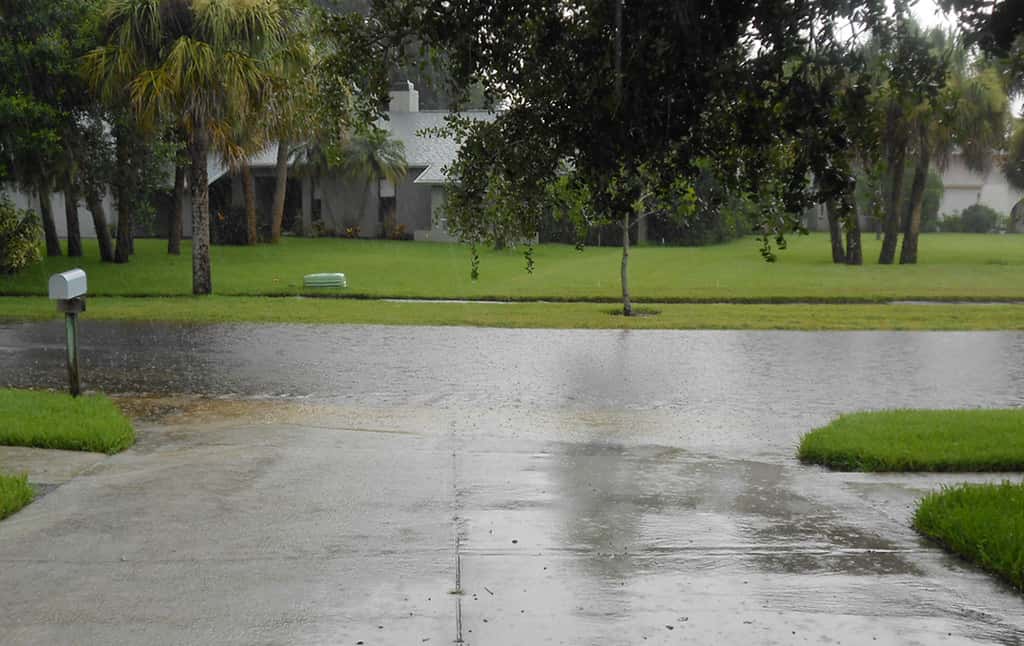
Parts of Palm Beach County have absorbed more than 10 inches of rain over three days as a slow-moving area of low pressure over the eastern Gulf keeps South Florida under repeated rounds of heavy downpours, with forecasters warning that the flood threat will persist into at least the middle of the week. The National Weather Service placed South Florida under a marginal risk of flash flooding, level 1 on the agency's four-step scale, with scattered to numerous showers and thunderstorms expected to continue south of Lake Okeechobee.
The system carries no tropical designation and is not associated with any named storm. It is, nonetheless, the most disruptive weather Florida has faced in weeks, and it illustrates a pattern that emergency managers have tried for years to communicate: the state's worst flooding often arrives without a hurricane attached to it.
Flood advisories cycled in and out across Broward, Miami-Dade and Palm Beach counties through the weekend as individual storm cells parked over urban drainage basins. In one advisory, forecasters reported between 1.5 and 2.5 inches of rain already on the ground with an additional 1 to 2 inches expected, a combination sufficient to produce minor flooding on roads and in low-lying neighborhoods.
What is driving the pattern
The culprit is a strong upper-level low, a pocket of cold air aloft that destabilizes the atmosphere and allows thunderstorms to build to unusual heights. Positioned over the eastern Gulf, the feature has functioned as a slow-turning engine, pulling deep tropical moisture across the peninsula and wringing it out over the same neighborhoods day after day.
What makes these systems dangerous is not the intensity of any single storm but the movement, or lack of it. Forecasters described storms moving slowly and erratically, which is the condition that turns an ordinary afternoon downpour into a flood event. A cell producing 2 inches of rain per hour is a nuisance if it is traveling at 30 mph and a serious problem if it is nearly stationary.
Rainfall totals of 1 to 1.5 inches were expected across most of South Florida, with isolated amounts of 4 to 6 inches possible. In West Palm Beach and surrounding communities, where more than 10 inches had already fallen over the preceding three days, the ground has little remaining capacity to absorb anything.
Where the flooding has hit hardest
Palm Beach County has borne the heaviest totals, and the effect compounds. Saturated soil, full retention ponds and canals already running high leave the region's engineered drainage system with minimal margin. Urban South Florida is particularly vulnerable because so much of the surface is impervious, sending runoff into storm drains rather than into the ground.
Broward County saw its own round of severe weather as the weekend closed out. The National Weather Service tracked a strong thunderstorm over Lauderdale Lakes, near Tamarac, moving north at roughly 10 mph, with warnings that heavy rain could trigger localized flooding. That slow forward speed is precisely the profile that produces street flooding in the region's older neighborhoods.
Flood warnings extended beyond the southeast corner of the state as well. A separate flood warning covered rivers in other parts of Florida, including the Withlacoochee River at Dunnellon, where the concern is riverine flooding driven by upstream runoff rather than the flash flooding that affects urban South Florida. The two hazards behave differently: flash flooding arrives within minutes and recedes quickly, while river flooding can crest days after the rain has stopped.
Why this is not a hurricane story
The 2026 Atlantic hurricane season has been extraordinarily quiet, producing six named storms and no Florida landfall. Tropical Storm Fay, the season's sixth, was spinning near the Azores more than 2,700 miles away as South Florida flooded. There is no connection between the two systems.
That disconnect is the point worth absorbing. Floridians have been trained by years of storm coverage to associate flood risk with the cone of uncertainty and a named system, but the state's rainfall climatology does not cooperate. The wet season runs from roughly May through October, and the heaviest single-day rainfall totals in many Florida cities were produced by systems that never carried a name.
The insurance consequences follow the same logic. Standard homeowners policies in Florida do not cover flood damage, and a non-tropical rain event does not change that. Coverage comes through the National Flood Insurance Program or the private flood market, and the federal program's authorization is set to expire on September 30 absent action by Congress.
What officials are telling residents
Guidance during a flood event is straightforward and, in practice, widely ignored. Motorists are urged not to drive through standing water, because road surfaces beneath it may be undermined and the depth is nearly impossible to judge from a driver's seat. Most flood fatalities in the United States occur in vehicles.
Residents in flood-prone areas have been advised to move vehicles to higher ground before the next round of storms and to clear debris from swales and storm drains near their properties. Local drainage failures during heavy rain frequently trace back to blocked inlets rather than to system capacity.
Gov. Ron DeSantis declared September as Florida Preparedness Month, and the current pattern makes the timing apt in a way officials may not have anticipated. The supplies that matter in a flood event differ somewhat from hurricane kits, with an emphasis on documentation, elevated storage for valuables, and knowing whether a property sits in a designated flood zone.
The broader flood exposure question
South Florida's vulnerability is structural. Much of the region sits only a few feet above sea level on porous limestone, which means groundwater rises along with the tide and limits how much water the ground can take. Rainfall that would drain away in other states has nowhere to go.
Sea-level rise compounds the arithmetic over time by reducing the gradient that gravity-fed drainage systems depend on. Water management districts have invested in pump stations to compensate, but pumps are expensive, require power, and address only the areas they serve.
Repeated rain events like the current one function as stress tests. They reveal which neighborhoods flood at 4 inches and which hold at 8, information that shapes capital planning, flood zone mapping and, eventually, insurance pricing for tens of thousands of South Florida households.
Roads, schools and daily disruption
The practical toll of a multi-day rain event in South Florida shows up first on the roads. Interstate 95 and the region's arterial surface streets develop standing water at predictable low points, and crashes climb sharply during the first minutes of heavy rain as oil and rubber lift off warm pavement. Law enforcement agencies across the tri-county area reported elevated crash volume through the weekend rounds of storms.
School operations absorb the disruption next. South Florida's school districts run some of the largest bus fleets in the country, and flooded pickup points force route changes that ripple through morning schedules. Districts generally keep campuses open during rain events, reserving closures for tropical systems, which means the burden shifts onto parents and drivers navigating flooded neighborhood streets.
Outdoor work stops. Construction sites shut down when lightning is within striking distance, and South Florida's building boom means tens of thousands of workers lose hours during extended unsettled stretches. Agriculture south of Lake Okeechobee faces its own exposure, with saturated fields delaying planting and raising disease pressure in crops already in the ground.
How this stacks up against past rain events
Ten inches in three days is a significant total but not an unprecedented one for South Florida in September. The region's wet season regularly produces multi-day totals in that range, and the most severe recent events have delivered comparable amounts in a fraction of the time. Rainfall intensity, measured in inches per hour, determines whether a total becomes a disaster.
What distinguishes the current pattern is duration rather than peak intensity. A stalled upper-level low can keep a region under storms for four or five consecutive days, and the cumulative effect on soil moisture, canal levels and groundwater is different from a single extreme burst. Drainage systems designed around a defined storm event handle a one-day deluge better than a week of steady loading.
Water managers watch canal stages closely during these stretches. The South Florida Water Management District operates an extensive network of canals, gates and pump stations, and preemptive drawdowns ahead of forecast rainfall are the primary tool for creating storage capacity. That strategy works well with advance notice and poorly when storm placement shifts day to day, which is exactly the situation an erratic upper-level low creates.
Longer-term, the region's exposure is being re-evaluated through infrastructure planning rather than forecasting. Local governments across the tri-county area have moved stormwater capacity to the front of their capital improvement lists, and several have commissioned basin-level studies to identify which neighborhoods flood first and why. Those studies are slow, expensive and politically difficult, because the answers frequently point toward properties that were permitted decades ago in places that should not have been developed.
What's next
Forecasters expect conditions to remain unsettled through at least midweek as the upper-level low maintains its position over the eastern Gulf. Until the feature moves or weakens, the daily pattern of scattered to numerous storms, particularly south of Lake Okeechobee, is likely to repeat.
Any additional heavy rainfall will fall on ground that is already saturated, which lowers the threshold for flooding with each successive day. Areas that handled the first 5 inches without incident may not handle the next 2.
Residents can monitor conditions through the National Weather Service forecast office in Miami and through county emergency management channels, which issue the localized road closure and drainage information that regional forecasts cannot capture. Flood advisories in South Florida are frequently issued with less than an hour of lead time, making real-time alerts more useful than daily forecasts.
Spotted an issue with this article?
Have something to say about this story?
Write a letter to the editor