Flood Watches Stretch From St. Augustine to Miami as Florida's East Coast Braces for Up to a Foot of Rain and 12-Foot Surf
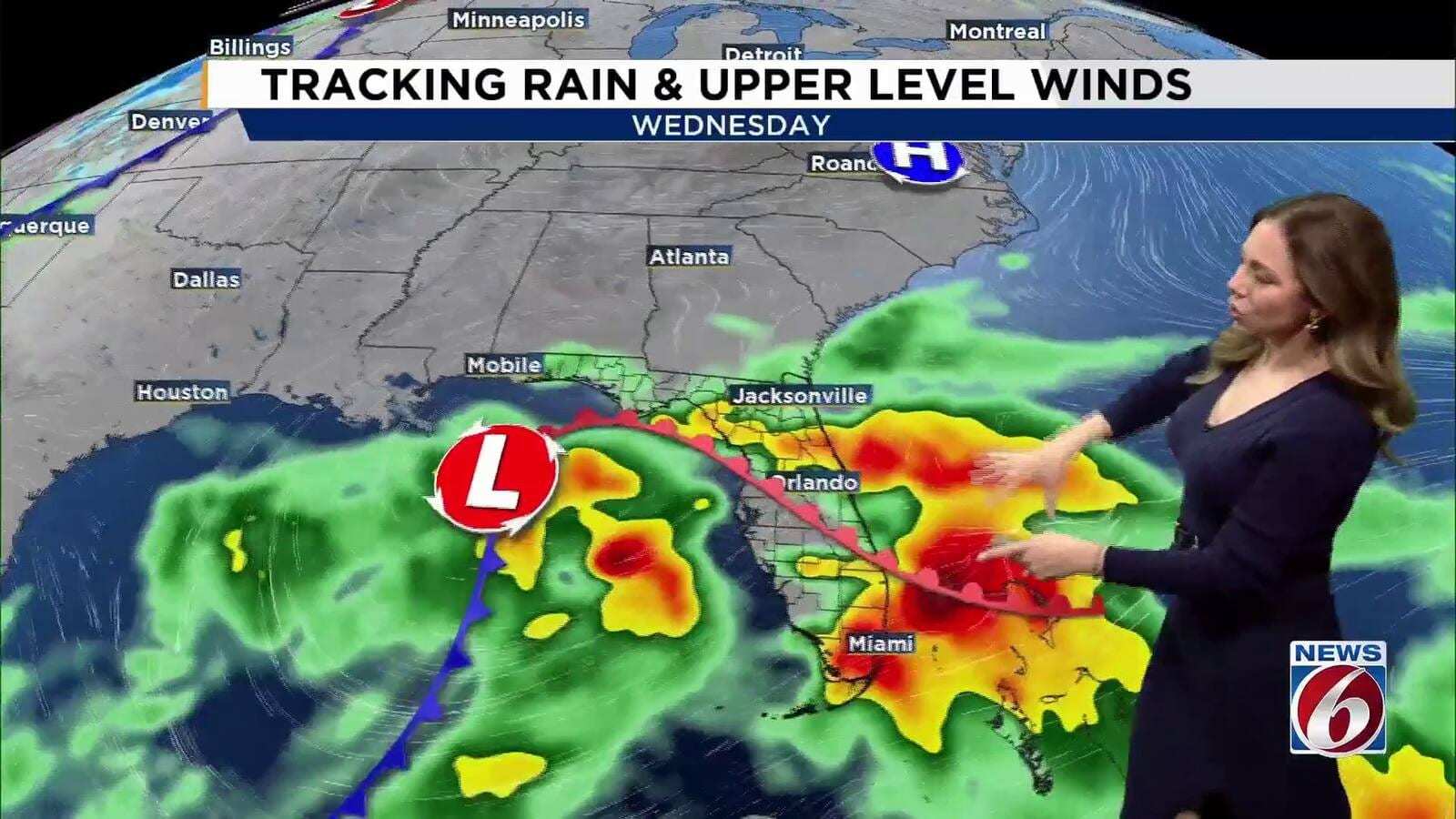
Flood watches now cover nearly the entire Atlantic side of the Florida peninsula, from St. Johns and Flagler counties in the northeast to Miami-Dade County in the south, as the National Weather Service warns that repeated bands of heavy rain could drop 3 to 6 inches across much of the region and as much as 8 to 12 inches in isolated coastal spots by the end of the week. In South Florida, forecasters in Miami say some neighborhoods could top 10 inches.
The rain arrives on top of a coastline already battered by strong onshore winds, high surf and life-threatening rip currents, and in communities that have not recovered from historic flooding earlier this month. The St. Johns River remains in major flood near Cocoa, and Palm Bay residents who lost homes to the Nov. 2 deluge were still asking on Monday when federal disaster aid would arrive.
Where the flood watches are and how much rain is forecast
Three National Weather Service offices issued flood watches on Tuesday, Nov. 17. The Miami office's watch is the shortest, ending Thursday evening; the Melbourne and Jacksonville watches run through Friday evening. The table below summarizes each office's watch area, timing and rainfall forecast as posted Tuesday.
| Area | NWS office | Watch timing | Forecast rainfall |
|---|---|---|---|
| Miami-Dade, Broward and Palm Beach counties | Miami | 1 p.m. Tuesday through Thursday evening | 2 to 4 inches; 6 to 8 inches possible, isolated totals over 10 inches |
| Volusia, Seminole, Orange, Osceola, Okeechobee, Brevard, Indian River, St. Lucie and Martin counties | Melbourne | Tuesday afternoon through Friday evening | 3 to 6 inches; localized 8 to 12 inches, mainly in coastal counties |
| St. Johns and Flagler counties | Jacksonville | Tuesday afternoon through Friday evening | 4 to 6 inches likely; localized 7 to 12 inches |
The Miami office said storms could produce rainfall rates of 1 to 2 inches per hour and that flooding is most likely in poorly drained and urban areas. In its morning forecast discussion, the office said the most likely outcome is 2 to 4 inches along the east coast through Friday, with a reasonable worst case of 6 to 10 inches, and that the highest totals are currently expected over coastal Palm Beach and Broward counties, which sit closest to a stalled boundary. Forecasters there cautioned that rainfall driven by coastal convergence is hard for computer models to pin down, and NBC 6 reported that the Miami office described relatively high uncertainty in exactly where the heaviest rain will fall.
In East Central Florida, the Melbourne office said the greatest flooding potential is along the coast. The federal Weather Prediction Center placed much of that coastline under a Moderate Risk, level 3 of 4, for excessive rainfall on Wednesday, with a Marginal to Slight Risk on the other days, according to the Melbourne forecast discussion. WKMG News 6 reported rain chances of 60% to 80% on Wednesday and Thursday as bands push inland off the ocean, and singled out Wednesday as particularly concerning for flooding.
Farther north, the Jacksonville office said waves of coastal showers with heavy rain at times would affect the Northeast Florida coast through the end of the week, with localized flooding possible in St. Johns and Flagler counties beginning Tuesday evening. Southeast Georgia is expected to stay mostly dry and cooler.
On the Gulf side, the Florida Public Radio Emergency Network, in a forecast published by WUSF, said rain chances in the Tampa Bay area would rise starting Tuesday, with showers through Wednesday and Thursday and the potential for isolated flooding in poorly drained areas.
What is driving the rain
Strong high pressure over the Appalachians and the mid-Atlantic is pressing against lower pressure over the Gulf, the Florida Straits and the western Atlantic, according to the Melbourne office. That tight pressure gradient is pushing steady easterly winds and deep moisture onto the coast, where showers form over the ocean and train onshore in repeated rounds. A weakening low and a disturbance aloft over the Gulf are adding lift.
The Melbourne office said an area of low pressure is expected to develop near the northern Bahamas and move north, parallel to the Florida east coast, Friday into Saturday. Winds should ease and gradually turn to the northeast and then the north and northwest over the weekend as that low passes, and rain chances should taper into early next week, although hazardous coastal and marine conditions are expected to continue.
Dangerous surf, rip currents and beach erosion
Every Atlantic beach from Nassau County to Miami-Dade County is under a high rip current risk, and most are also under high surf advisories. The Melbourne office warned of rough, pounding surf with moderate to locally major beach erosion and strongly discouraged anyone from entering the water. Sustained easterly winds of 15 to 20 mph with gusts of 25 to 30 mph are forecast along the central coast, with occasional gusts near 35 mph, and downpours could briefly bring gusts of 30 to 45 mph.
The coastal advisories in effect Tuesday are summarized below.
| Coastline | Hazard | Timing |
|---|---|---|
| Nassau, Duval, St. Johns and Flagler | Breaking waves of 7 to 10 feet; high rip current risk | Surf advisory 7 p.m. Tuesday to 2 p.m. Thursday |
| Volusia, Brevard, Indian River, St. Lucie and Martin | Breaking waves of 5 to 10 feet; high rip current risk | Surf advisory 7 p.m. Tuesday to 1 p.m. Thursday |
| Palm Beach and Broward | Breaking waves of 7 to 12 feet; high rip current risk | Through 7 p.m. Thursday |
| Miami-Dade | High rip current risk | Through Thursday evening |
| Upper Florida Keys | Minor saltwater flooding of low streets and lots | Through late Tuesday night |
| Escambia, Santa Rosa and Okaloosa | Breaking waves of 5 to 6 feet; high rip current risk | Through Thursday night |
Offshore, the Miami office forecast Atlantic seas climbing to 10 to 12 feet Tuesday, and the Melbourne office said seas off East Central Florida could build to 8 to 13 feet Wednesday and Thursday, with a small craft advisory in effect and a possible gale watch or warning under consideration. In the Upper Keys, the Key West office warned that some seawalls and docks could be overtopped and storm drains could overflow around high tide.
St. Johns River still in major flood near Cocoa
The new rain will fall on a river basin that is already overflowing. The St. Johns River near Cocoa stood at 17.1 feet Monday evening, above its 16-foot flood stage and in the major flood category, and the Weather Service expects it to hold near that level through mid to late week. At 17.2 feet, the agency says, water enters homes along the river in the Lake Poinsett area west of Cocoa and low-lying homes in Rockledge's Silver Pines subdivision and the Shakespeare Park area of Cocoa, and the Providence Road area west of Cocoa becomes impassable.
Upstream of Lake Harney in Seminole County, the river was at 9.0 feet, a foot above flood stage and in moderate flood, a level at which water enters the first floor of homes on Whitcomb Drive. Downstream at Astor, on the Volusia and Lake county line, the river was in minor flood at 2.6 feet and is forecast to rise to moderate flood stage later in the week as this week's rain and northerly winds push more water into the system. The Melbourne office said in its Tuesday key messages that extensive flooding continues along the St. Johns because of exceptional rainfall in the upper basin over previous weeks.
Palm Bay reopens a road, and residents ask about FEMA
In Palm Bay, where WESH reported that a catastrophic 24 hours of rain washed out Port Malabar Road on Nov. 2, the city reopened the road on Monday after about two weeks of repairs. Mayor Rob Medina credited the contractor, Cathcart, with putting crews on the job day and night, according to WESH.
The ribbon cutting turned tense. WKMG News 6 reported that frustrated residents chanted "Where is FEMA?" as officials spoke, and that U.S. Rep. Mike Haridopolos, whose district includes Palm Bay, said he would keep working with the president to make sure a federal disaster declaration covers individuals and not only the city, county and state. WESH reported that the state submitted its request for federal assistance the week before and that Haridopolos estimated the review could take a few weeks. No approval had been announced as of Tuesday.
Some residents told News 6 they did not trust that the repaired road would hold up under another round of heavy rain. Medina said the city was working to set up local sandbag sites, and Haridopolos said officials wanted canals lowered so they would not overflow again.
Sandbag sites in Brevard County
Brevard County sandbag distribution sites are open from 7 a.m. to 6 p.m. on Tuesday and Wednesday, according to News 6, at three locations:
- Phantom Fireworks, 2725 W. King St., Cocoa
- New Shiloh Christian Center, 3900 Sarno Road, Melbourne
- Eastern Florida State College, Palm Bay campus, 250 Community College Parkway
In Titusville, the city opened a self-serve sandbag station at 385 N. Singleton Ave. It is open 24 hours a day with free sand and empty bags and a limited number of shovels, but it is not staffed and not lit at night, and the city asked residents to take only what they need, News 6 reported. Titusville largely escaped this month's Palm Bay flooding but suffered its own historic flood in October 2025, and residents of the area told the station they were stacking sandbags again. One resident of nearby Mims said water came within half an inch of entering her home last week, more than a year after a flood that destroyed her furniture and a car.
What's next
Wednesday and Thursday are the days of greatest concern from Cape Canaveral south to Miami, according to forecasters, while Northeast Florida's heaviest bands are expected to persist into Friday. The South Florida watch expires Thursday evening and the Central and Northeast Florida watches on Friday evening, though any of them can be extended. The Weather Service urges residents not to drive through flooded roads and to watch for flood warnings if several rounds of heavy rain hit the same neighborhoods.
Rough surf and rip currents are expected to linger into the weekend, especially in Northeast Florida, as the low near the Bahamas moves up the coast. River forecasts for the St. Johns are posted by the Melbourne office at water.noaa.gov, and Palm Bay flood victims are waiting on FEMA's decision on the state's request for federal aid.
Spotted an issue with this article?
Have something to say about this story?
Write us a letterComments
No comments yet. Be the first to weigh in.
Related Coverage
Hurricane Isaias Insured Losses Climb Past $735.5 Million as Claims Reach 68,071 in Florida
5d ago
Frost Advisories Cover North Florida as Coldest Morning of the Season Arrives Sunday, With 40s Reaching Orlando and Tampa
6d ago
St. Johns River Hits Major Flood Stage Near Cocoa as Seminole County Braces for Weeks of High Water and a Late-November Crest
Nov 6
NOAA Retires the NAM, the Forecast Model Known for Overhyping Florida Hurricanes, in Favor of the Rapid Refresh Forecast System
Nov 5