Forecasters Watch Invest 92L as the Atlantic Wakes Up in Peak Hurricane Season
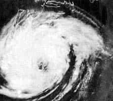
The National Hurricane Center is tracking a disturbance in the central tropical Atlantic designated Invest 92L, giving it a high probability of developing into a tropical depression in the coming days as the Atlantic basin enters the climatological peak of hurricane season.
The system is located well east of the Caribbean, roughly 800 miles southwest of the Cabo Verde Islands according to forecast discussions, and has been tracking generally westward across open ocean. Forecasters have assigned it development odds in the high range over the next several days, with a tropical depression considered likely to form as environmental conditions remain favorable.
Invest 92L poses no immediate threat to Florida. It sits thousands of miles from the Florida peninsula, and the near-term forecast track carries it west to west-northwest toward the vicinity of the Lesser Antilles rather than into the Gulf. Forecasters have indicated that environmental conditions are expected to turn hostile as the system approaches the islands, with weakening considered likely by the end of the week.
What an invest actually is
The term invest is shorthand for an area of investigation. It is an administrative designation the National Hurricane Center applies to a disturbance so that forecast models and data collection systems can be focused on it. An invest number does not mean a storm has formed, and it does not carry any watch or warning implication.
Numbering runs from 90 to 99 and recycles through the season, which is why the same numbers reappear across different years and different systems. A designation of 92L means the twelfth or so system flagged for detailed model attention in the Atlantic basin during the current cycle.
Most invests never become named storms. The designation simply signals that forecasters consider a disturbance organized enough, or positioned favorably enough, to justify running the specialized model suite that produces the track and intensity guidance the public later sees as spaghetti plots.
The distinction matters for Florida readers because invest-stage systems generate the widest spread of model solutions, and individual model runs at that stage carry little predictive value. The National Hurricane Center's official forecast, issued in its tropical weather outlooks and, once a system is named, in numbered advisories, is the authoritative product.
Where the 2026 season stands
The 2026 Atlantic hurricane season has been quiet by historical standards. Through mid-August, the basin has produced two named tropical storms, Arthur and Bertha, and no hurricanes.
That tracks with the seasonal forecast. NOAA predicted a below-normal Atlantic season for 2026 and maintained that call in its updated outlook, projecting 7 to 13 named storms, of which 2 to 6 could reach hurricane strength and 0 to 2 could become major hurricanes of Category 3 or higher. NOAA assigned a 75 percent chance of below-normal activity, a 20 percent chance of a near-normal season and a 5 percent chance of an above-normal season.
Two named storms by mid-August is behind the long-term average pace, but the calendar matters. The Atlantic season runs from June 1 through November 30, and climatologically the most active stretch falls between mid-August and mid-October. Roughly the majority of named storm activity in a typical season occurs after August 15.
Florida's most damaging landfalls have historically clustered in this window. The state's hurricane history is a reminder that a below-normal season is a statement about basin-wide activity, not about any individual community's risk. A quiet season with one landfalling storm is a catastrophic season for the county that takes the hit.
What Florida emergency managers are doing
County emergency management offices across Florida have kept seasonal preparations running through the quiet stretch. In Manatee County, self-service sandbag locations have remained open at several sites, with officials reminding residents over the weekend that the busiest portion of the season is underway.
Similar programs operate in coastal counties statewide, typically activated ahead of a specific threat but in some jurisdictions maintained on a standing basis through the season. Residents can confirm site locations, hours and bag limits through their county emergency management office.
The Florida Division of Emergency Management coordinates state-level response and maintains the state's disaster preparedness guidance, including recommended supply lists and evacuation zone lookup tools. Evacuation zones in Florida are assigned by county and are based on storm surge vulnerability rather than wind, which is why a resident several miles inland may be in a different zone than a neighbor a few blocks away.
Watches, warnings and what they mean
Terminology precision matters when a system does threaten. A tropical storm or hurricane watch means those conditions are possible within the specified area, generally within 48 hours. A warning means those conditions are expected within the area, generally within 36 hours. A watch is the signal to finalize preparations; a warning means the window to act safely is closing.
Storm surge watches and warnings are issued separately from wind products, because surge and wind risk do not always align geographically. A community can face a life-threatening surge forecast under a tropical storm wind warning, and the surge product is the one that drives evacuation decisions in most Florida coastal counties.
Evacuation orders themselves come from county emergency management, not from the National Hurricane Center, and they are issued by zone. An evacuation order covering Zone A in a county does not mean every resident of that county is being told to leave. Residents should know their zone before a storm threatens rather than looking it up during an advisory cycle.
What it means for Floridians
For now, Invest 92L is a system to be aware of rather than one to prepare for. Its forecast track keeps it in the open Atlantic and toward the eastern Caribbean, and the intensity guidance points toward weakening as it encounters less favorable conditions.
The practical takeaway is seasonal rather than storm-specific. Mid-August is the point in the calendar when Florida households should have supplies assembled, insurance documentation accessible, evacuation zones confirmed and a plan for pets, medication and people with mobility needs.
Property owners should also note that most homeowners policies impose a hurricane deductible calculated as a percentage of dwelling coverage rather than a flat dollar amount, and that flood damage is excluded from standard homeowners policies. National Flood Insurance Program policies generally carry a 30-day waiting period before taking effect, which means a policy purchased when a storm appears on the forecast map will not cover that storm.
How Florida's insurance market prepares for a season
Hurricane season is a financial event for Florida as much as a meteorological one, and the state's insurance market carries structures designed specifically for it.
Florida carriers purchase reinsurance, which is insurance for insurers, to cover losses above a retention level. Reinsurance is priced globally and renews on a calendar that concentrates around June 1, the start of hurricane season, which is why reinsurance market conditions in the spring translate directly into Florida premium levels for the following year.
The Florida Hurricane Catastrophe Fund provides state-backed reinsurance at rates below the private market, funded through premiums paid by participating insurers and, if needed, through assessments and bonding. It is a central pillar of the market's capacity to absorb a major storm.
Citizens Property Insurance operates as the residual market carrier for property owners unable to obtain coverage privately. Its policy count has fallen substantially through depopulation programs that transfer policies to private carriers, and it is no longer the largest property insurer in the state.
A quiet season improves all of these positions. Reinsurance capital that is not consumed by losses remains available for the following year, which moderates renewal pricing. Two consecutive quiet seasons compound that effect. A single major landfall reverses it.
What preparation actually looks like
Emergency management guidance for Florida households is specific, and the recommendations reflect what actually fails during and after a storm.
- Water at one gallon per person per day for at least seven days, plus water for pets.
- Non-perishable food requiring no cooking, and a manual can opener.
- Prescription medications with enough supply to cover an extended outage or evacuation.
- Battery-powered or hand-crank radio for information when cellular networks fail.
- Flashlights and batteries rather than candles, which are a leading cause of post-storm residential fires.
- Cash, since card systems fail without power and network connectivity.
- Full fuel tanks before a storm, since stations cannot pump without electricity.
- Documents including insurance policies, identification and property records, photographed and stored where they can be accessed remotely.
Photographing the interior and exterior of a property before a storm creates a dated record that materially strengthens an insurance claim, and it takes a few minutes.
Households with medical equipment requiring electricity should register with their county's special needs registry well before a storm, since those programs coordinate sheltering and evacuation assistance and require advance enrollment.
What's next
The National Hurricane Center issues its Atlantic tropical weather outlook several times daily and increases the cadence when systems approach land. If Invest 92L reaches tropical depression strength it will receive a number, and if it reaches tropical storm strength it will receive the next name on the 2026 Atlantic list.
Forecasters have also flagged additional areas of the basin for monitoring as the main development region becomes more active, which is typical for the second half of August. Residents should expect more invest designations in the coming weeks and should treat each one as a prompt to check preparations rather than as a forecast of impact.
Official information is available from the National Hurricane Center, from local National Weather Service forecast offices in Miami, Tampa Bay, Jacksonville, Melbourne, Key West, Tallahassee and Mobile, and from county emergency management agencies. Those are the sources that carry watches, warnings and evacuation orders.
Spotted an issue with this article?
Have something to say about this story?
Write a letter to the editorComments
No comments yet. Be the first to weigh in.
Related Coverage

King Tides Set Record at Port Everglades Gauge, Flooding Streets From Fort Lauderdale to Miami Beach
7h ago
Florida's First Fall Cold Front Delivers Cooler Air and Strong Coastal Winds as a Nor'easter Develops Offshore
4d ago
Tropical Storm Hanna Forms Far From Florida as Atlantic Stays Hurricane-Free
6d ago
Hurricane Season Enters Its Final Weeks With Six Named Storms and No Atlantic Hurricanes
Sep 23