Saharan Dust Plume Hazes Florida Skies and Suppresses Tropical Development
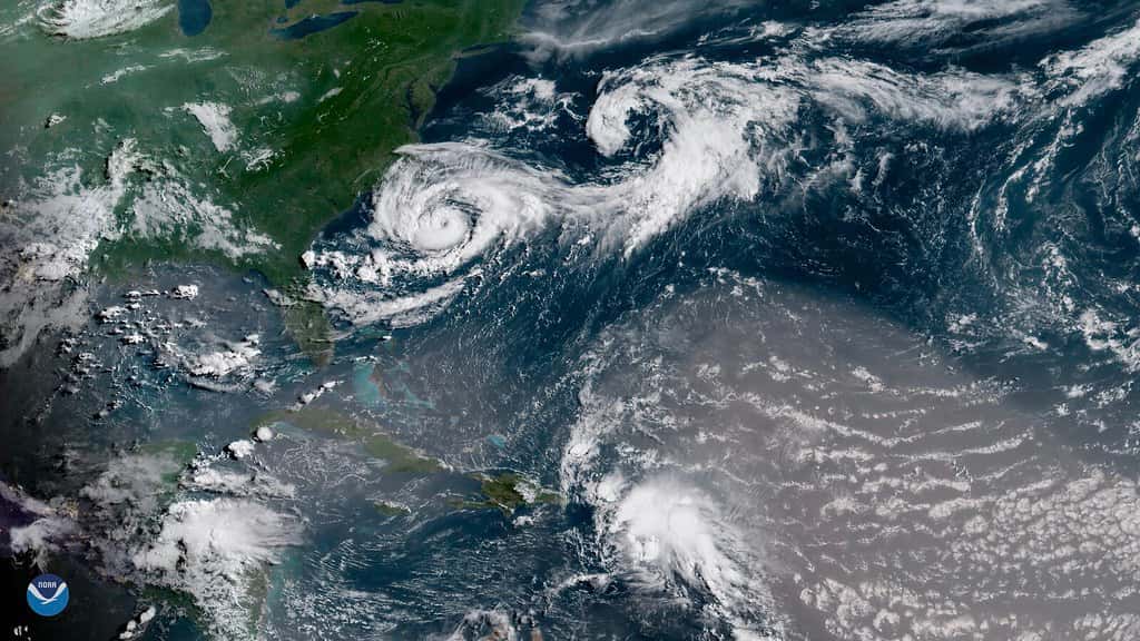
A large plume of Saharan dust that crossed the Atlantic is spreading over Florida this week, hazing skies from the Keys to the Panhandle, degrading air quality for sensitive groups and cutting into the state's normal afternoon storm chances. A second plume is expected to reach the state late in the week and into the weekend, with concentrations forecast to increase into early next week. The same dry, dusty air is one of the reasons the National Hurricane Center is not expecting tropical cyclone formation anywhere in the Atlantic basin over the next seven days.
What the Saharan Air Layer is
The Saharan Air Layer is a mass of extremely dry, dusty air that forms over the Sahara Desert and is carried westward across the Atlantic by the prevailing trade winds. It typically sits between roughly 5,000 and 20,000 feet in the atmosphere and can span thousands of miles in a single outbreak. New surges emerge off the African coast every three to five days during the peak of the season, and outbreaks are most frequent from late spring through early fall, peaking from late June into mid-August.
Reaching Florida requires the plume to survive a journey of more than 5,000 miles, and most do not arrive at full strength. Larger particles fall out over the ocean during the transit, so what reaches the Gulf Coast and the Florida peninsula is the fine fraction, particles small enough to remain suspended for a week or more. Even in weakened form it is enough to visibly alter the sky and to register on air quality monitors across the state.
It remains common at the start of August for large amounts of Saharan dust to travel all the way across the Atlantic and reach the United States. Current plumes have extended over the Caribbean and Cuba, through the Gulf and into Florida, a track that is typical for this point in the calendar. The phenomenon has been observed and studied for decades, and satellite instruments now track individual plumes from the moment they leave Africa.
Air quality and health effects
The most immediate effect for Floridians is respiratory. Dust outbreaks push fine particulate levels higher, and forecasters have flagged poor air quality across the Tampa Bay area and other parts of the state as the plume settles in. People with asthma, chronic obstructive pulmonary disease, allergies or cardiovascular conditions are the most likely to notice symptoms, and children and older adults are generally more sensitive than the population at large.
Typical complaints during a dust event include throat irritation, coughing, itchy or burning eyes, sinus congestion and shortness of breath during exertion. Health guidance during these episodes is straightforward: sensitive groups should limit prolonged outdoor exertion, keep windows closed and run air conditioning with a clean filter, and keep rescue inhalers accessible. Filters rated MERV 13 or higher capture a greater share of fine particulate than standard filters.
Outdoor workers, youth sports programs and anyone exercising outside in the middle of the day face the most exposure. Because Florida summer heat already imposes its own limits on outdoor activity, the practical advice largely overlaps with standard heat guidance: shift strenuous activity to early morning and take breaks indoors. School athletic programs in Florida operate under heat policies that can be adapted for air quality without new procedures.
Why it quiets the tropics
Tropical cyclones need deep, moist air through the full depth of the troposphere to develop. The Saharan Air Layer supplies the opposite. Its extreme dryness, often below 20 percent relative humidity at levels where a developing system needs saturated air, starves thunderstorm clusters of the moisture they require, and dry air entrained into a disturbance causes convection to collapse and the system to weaken.
The layer also carries a strong temperature inversion at its base, sometimes called the trade wind inversion, which caps rising air and inhibits the deep convection a tropical wave must sustain to organize. On top of that, the surge of air associated with a dust outbreak typically brings enhanced vertical wind shear of 25 knots or more, which displaces the thunderstorm activity from the low-level circulation and tears apart the vertical structure a young system needs.
Those factors line up with the current forecast picture. The National Hurricane Center's tropical weather outlook issued Tuesday morning indicated that tropical cyclone formation is not expected during the next seven days across the North Atlantic, the Caribbean Sea and the Gulf. NOAA's seasonal outlook issued in May called for a below-normal 2026 Atlantic season, projecting 8 to 14 named storms and 3 to 6 hurricanes, and cited a developing El Nino among the reasons for the suppressed forecast, since El Nino conditions generally increase Atlantic wind shear.
Other effects Floridians will notice
Sunrises and sunsets turn unusually vivid during dust events. Fine particles scatter shorter wavelengths of light, leaving deeper oranges and reds near the horizon and producing the kind of sky that fills social media feeds along both Florida coasts. The same scattering produces the milky, washed-out look of the midday sky that distinguishes a dust haze from ordinary summer humidity haze.
Rain during a dust outbreak can leave a fine gritty film on vehicles and outdoor surfaces, sometimes described as dirty rain. It is cosmetic rather than hazardous, though it is a nuisance for car owners, for anyone with a screened pool enclosure, and for outdoor furniture and solar panels, where accumulated dust measurably reduces output until it is washed off.
There is an environmental angle as well. Saharan dust carries iron, phosphorus and other nutrients, and researchers have long studied whether dust deposition contributes to algal blooms in Florida waters, including red tide along the Gulf coast. That relationship is complex and not the sole driver of any given bloom, but it is one of the reasons dust outbreaks draw attention from marine scientists working on red tide and coral reef health. Dust deposition has also been linked to nutrient delivery to the Amazon basin, an illustration of how far the effects of these plumes reach.
The heat consequence
The lower rain chances that accompany a dust event carry a temperature cost. Afternoon thunderstorms are Florida's natural air conditioning in summer, and their arrival typically drops surface temperatures by ten degrees or more within minutes. Days without them tend to run hotter for longer, pushing heat index values up through the late afternoon rather than breaking in the middle of the day.
That matters because Florida heat is already a serious health risk in August. Heat-related emergency department visits rise sharply during stretches without afternoon convection, and outdoor workers in construction, agriculture and landscaping bear the greatest exposure. Combining elevated heat with degraded air quality compounds the risk for anyone with a cardiopulmonary condition.
Water demand and electricity demand both rise during these periods as well. Utilities across Florida see peak load climb during hot, dry stretches, and lawn irrigation increases in the absence of natural rainfall, which can bring water restrictions into play in districts operating under conservation rules.
What it means for the rest of the summer
The suppression of tropical activity is temporary and should not be mistaken for a season-long reprieve. Saharan dust outbreaks weaken through August as the atmospheric pattern that drives them shifts, and the Atlantic season's climatological peak falls in early to mid September, well after the dust influence typically fades.
A quiet stretch in early August is a normal feature of the calendar, not an anomaly. Florida emergency managers routinely use these windows to encourage residents to complete preparations rather than to relax them, since the historical distribution of Florida landfalls is heavily weighted toward late August through October. Several of the most damaging storms in state history made landfall after a quiet early season.
Seasonal forecasts also carry an important limitation. A below-normal season forecast says nothing about landfall risk for any particular location. Quiet seasons have produced devastating Florida landfalls, and active seasons have passed without a single United States hurricane strike. The number of storms and where they go are largely independent questions.
How forecasters track a plume
Satellite instruments provide the primary tracking tool, measuring aerosol optical depth to quantify how much dust is suspended in a given column of atmosphere. Those measurements produce the maps that show a plume crossing the Atlantic and allow forecasters to project arrival timing days in advance.
Ground-based monitoring supplements the satellite view. Air quality stations across Florida measure fine particulate concentration directly, and those readings are what determine the air quality index values that trigger health advisories for sensitive groups.
Weather balloon soundings reveal the vertical structure, showing the depth of the dry layer and the strength of the inversion at its base. Those profiles are what allow hurricane specialists to assess whether a given tropical wave is likely to survive its encounter with the dust and dry air.
What's next
Forecasters expect the current plume to be followed by a second surge arriving at the end of the week and into the weekend, with dust concentrations increasing late in the weekend and into early next week. Conditions should ease as the plume disperses, restoring more typical summer moisture and afternoon convection along the sea breeze boundaries.
Residents who want to track conditions can monitor local National Weather Service forecast offices in Miami, Tampa Bay, Jacksonville, Melbourne, Tallahassee and Key West, along with state and federal air quality reporting. Air quality indices update through the day and are the most direct measure of whether outdoor activity should be limited for sensitive groups.
Hurricane season runs through November 30. Florida Division of Emergency Management guidance remains unchanged during quiet stretches: maintain a supply kit with at least seven days of water and non-perishable food, know your evacuation zone and evacuation route, and confirm insurance coverage before a storm is named, since most policies impose a waiting period once a system is in the basin. The Florida Press will continue tracking the Atlantic basin and Florida weather conditions daily.
Spotted an issue with this article?
Have something to say about this story?
Write a letter to the editor