Strong fall cold front brings Florida Saturday rain, cooler air and dangerous surf this weekend
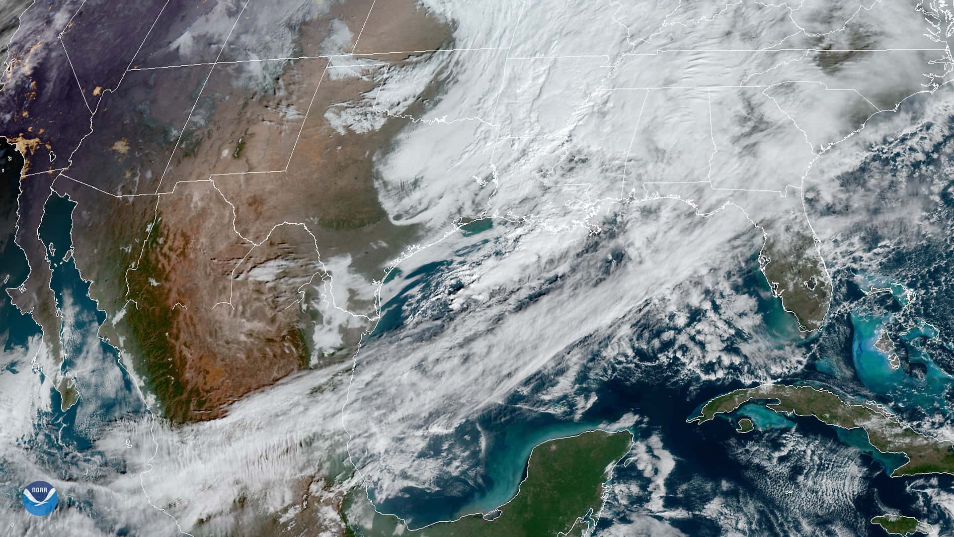
A strong fall cold front will sweep down the peninsula this weekend, bringing a wet Saturday for much of the state, then sharply cooler, less humid and windy air from Sunday into next week, according to National Weather Service forecasts issued Thursday, Oct. 15. The change follows a run of late-season heat, and it arrives with a warning for the coast: the same strong northeast winds that will clear out the humidity are expected to build dangerous surf, rip currents and rough seas on both the Atlantic and Gulf sides.
The tropics, meanwhile, are quiet for Florida. The National Hurricane Center said in its Thursday morning outlook that tropical cyclone formation is not expected in the Atlantic, Caribbean Sea or Gulf during the next seven days. The action has shifted to the Eastern Pacific, where Hurricane Trudy and Tropical Storm Simon are spinning off the coast of Mexico.
Timing of the front
The front is tied to a low pressure system over the Great Lakes, with the boundary trailing southwest through the Mississippi Valley to southeast Texas, the weather service office in Ruskin said. It is forecast to push through North Florida Friday night and down the peninsula on Saturday, reaching South Florida by Saturday evening into Sunday, where it is expected to stall.
Before it arrives, Thursday and Friday stay warm and increasingly humid. Highs are forecast in the upper 80s to low 90s across Central and South Florida. The Miami office warned of moderate to major HeatRisk to end the week, with heat index values of 100 to 105 degrees, noting that the region typically does not see that level of heat this late in the season.
Rain chances climb Friday as deep tropical moisture moves north. The Melbourne office forecast scattered to numerous afternoon and evening showers and storms Friday, with frequent lightning, gusts up to 45 mph and locally heavy rain of 1 to 3 inches possible. Tampa Bay forecasters expect scattered to numerous showers and storms from late Friday through Saturday evening as the front passes.
Saturday rain, then a cooldown
The heaviest and most widespread rain is expected Saturday, directly ahead of the front. In the Panhandle and Big Bend, the front is expected to pass largely dry, with the Tallahassee office calling for little to no chance of rain. Farther south, the picture is wetter. The Melbourne office put Saturday rain chances at 50 to 70 percent for much of east central Florida and flagged a Marginal Risk (Level 1 of 4) of excessive rainfall, especially along the Treasure Coast, where persistent bands of onshore showers could cause flooding.
In South Florida, the Miami office said rainfall totals remain uncertain, but a reasonable worst case of 2 to 4 inches on Saturday would likely mean only localized flooding. The Key West office forecast 2 to 4 inches, with isolated higher amounts, from Saturday through Tuesday, which could lead to localized flooding, especially at high tide.
Behind the front, temperatures drop noticeably. The Tampa Bay office expects well below average temperatures Sunday through most of next week, with highs in the mid-70s to mid-80s, lows in the low to mid-60s and dew points falling into the 50s north of Tampa Bay. In North Florida, the Tallahassee office forecast highs only in the mid-60s to mid-70s this weekend.
The weather service's point forecasts as of Thursday show how far the cooler air reaches.
| City | Sat. high | Sat. night low | Sun. high | Sun. night low |
|---|---|---|---|---|
| Pensacola | 72 | 55 | 72 | 57 |
| Tallahassee | 72 | 54 | 70 | 55 |
| Jacksonville | 74 | 62 | 72 | 64 |
| Orlando | 80 | 67 | 77 | 66 |
| Tampa | 80 | 66 | 78 | 67 |
| Fort Myers | 83 | 71 | 81 | 70 |
| Miami | 87 | 77 | 83 | 75 |
| Key West | 86 | 78 | 84 | 76 |
South Florida and the Keys will feel the least relief, since the front is expected to stall nearby, keeping clouds, showers and storms in the forecast there into early next week.
Wind and dangerous surf
Wind may be the bigger story than the cool air. A strong high pressure center, around 1036 millibars, is forecast to build near Virginia, setting up a tight pressure gradient over the peninsula and breezy to windy north and northeast winds for much of next week.
On the east coast, the Melbourne office said northerly winds will rise to 15 to 25 mph Saturday with gusts of 30 to 40 mph, strongest along the coast. Wind Advisories are likely for the coast Saturday and Saturday night and could expand inland on Sunday. In the Big Bend and Panhandle, the Tallahassee office expects gusts to 35 mph over land and 40 knots over coastal waters, especially Saturday.
The surf will turn dangerous. The Melbourne office forecast breaking waves of 9 to 12 feet over multiple tidal cycles, with moderate beach erosion, especially north of Cape Canaveral, and urged residents and visitors to stay out of the water starting this weekend. The Jacksonville office said local nor'easter conditions return, with a high risk of rip currents and rough, high surf from Saturday through much of next week, along with minor tidal flooding possible at the coast, along the Intracoastal Waterway and in the St. Johns River basin, where minor flooding could linger into next week.
Boating conditions
Boaters face hazardous conditions on both coasts. Off east central Florida, north and northeast winds of 20 to 30 knots Saturday are expected to strengthen to 25 to 30 knots Sunday, with frequent gale-force gusts and seas building to 10 to 14 feet by Saturday night. In the eastern Gulf, the Tampa Bay office expects north to northeast winds of 20 to 30 knots and seas up to 12 feet, with a Small Craft Advisory likely starting Saturday and lasting most of next week. The Key West office said a Small Craft Advisory will likely be needed by Sunday for some or all Keys waters.
A setback risk for Isaias recovery
In the Panhandle, the wind arrives as communities are still cleaning up from Hurricane Isaias, which Gov. Ron DeSantis said made landfall near Destin as a Category 2 storm. DeSantis said Tuesday that Florida's Isaias death toll had reached six. The Tallahassee office warned that this weekend's gusts could hamper recovery work, bringing down already damaged trees and causing new power outages, and could loosen improperly secured roof tarps and outdoor items.
The tropics
The hurricane center's Atlantic outlook showed no areas to watch through the next seven days. In the Eastern Pacific, Trudy strengthened into a hurricane with maximum sustained winds near 75 mph as of early Thursday and was forecast to rapidly intensify and approach southwestern Mexico as a major hurricane this weekend. Simon, a tropical storm with 60 mph winds, was nearly stationary south-southeast of the Baja California Peninsula. Neither poses a threat to Florida. Forecasters also gave a disturbance expected to form off southern Mexico next week a 30 percent chance of development over seven days.
The quiet Atlantic does not mean the season is over. The Atlantic hurricane season runs through Nov. 30, and October storms have historically struck Florida.
What's next
Forecasters said the details of next week depend on a low pressure system expected to develop near or well off the Mid-Atlantic coast, which could change wind direction and strength. Current guidance favors breezy northeast winds continuing through at least early next week, with temperatures slowly warming but staying near to below normal in Central Florida. North Florida is expected to stay dry and gradually warm, while South Florida and the Keys keep rain chances as the stalled front lingers. Check the forecast from your local National Weather Service office before heading to the beach or out on the water this weekend.
Spotted an issue with this article?
Have something to say about this story?
Write us a letterComments
No comments yet. Be the first to weigh in.
Related Coverage

Hurricane Center Gives Atlantic Low Near Cabo Verde a 20% Chance as Florida Gets a Break After Isaias
3d ago

Tallahassee and the Big Bend Escape Isaias' Worst, With Downed Trees, Brief Outages and Rising Rivers to Watch
6d ago

Isaias Death Toll Rises to Six as Florida Hits 95% Power Restored and Escambia Tallies $64 Million in Public Costs
6d ago

Panhandle Evacuations Widen From Perdido Key to St. George Island as Major Hurricane Isaias Nears
Oct 8