Quiet Atlantic Holds as Forecasters Cut 2026 Hurricane Outlook Again
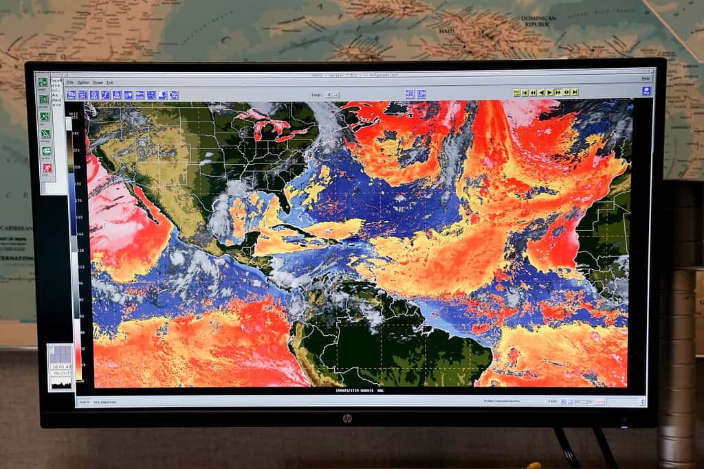
Florida is entering the final week of July with an unusually quiet Atlantic. The National Hurricane Center's Sunday tropical outlook indicated no tropical cyclone development expected anywhere in the basin over the following seven days, even as forecasters continued tracking four tropical waves moving west across the Atlantic and Caribbean.
That quiet is consistent with a season that forecasters have progressively downgraded. Colorado State University's July 8 update cut its 2026 Atlantic forecast to nine named storms, four hurricanes and one major hurricane of Category 3 strength or higher. That is well below the long-term average of roughly 14 named storms and seven hurricanes, and it represents the third reduction of the season: the team's April outlook called for 13 named storms, June's revision lowered that to 11, and July dropped it to nine.
The stated driver is El Nino. Forecasters cited a high likelihood of a strong El Nino event, which typically suppresses Atlantic hurricane activity by increasing vertical wind shear over the Caribbean and tropical Atlantic. CSU also put the probability of a major hurricane making landfall anywhere along the continental United States coastline at 17 percent, against a long-term average of 43 percent.
How El Nino suppresses Atlantic storms
El Nino is a periodic warming of sea surface temperatures in the central and eastern equatorial Pacific. Its effects reach the Atlantic through changes in the atmospheric circulation that spans the tropics.
The mechanism most relevant to hurricanes is vertical wind shear, the change in wind speed and direction with height. Tropical cyclones require a vertically stacked structure to organize and intensify. Warm, moist air rising through the storm's core must remain aligned from the surface through the upper troposphere. When upper-level winds blow substantially faster or from a different direction than surface winds, that structure is torn apart, and a developing system either fails to organize or weakens.
During El Nino years, enhanced convection over the Pacific alters the upper-level wind pattern across the Atlantic basin, increasing shear particularly over the Caribbean and the western tropical Atlantic. El Nino conditions also tend to increase atmospheric stability and mid-level dryness over the Atlantic, both of which work against development.
The seasonal forecasting skill built on this relationship is real. El Nino years have historically produced measurably fewer Atlantic named storms and hurricanes than neutral or La Nina years, which is why forecast teams weight the El Nino signal heavily.
The limit of a seasonal forecast
Here is the part that matters most for Floridians, and it is worth stating without hedging: a seasonal forecast predicts basin activity, not your risk.
A below-normal season is a statement about how many storms are likely to form across an entire ocean basin over several months. It says nothing about where any individual storm will go. Landfall is determined by steering currents present during the days a specific system exists, which are not predictable at seasonal timescales.
Florida's own history illustrates the point repeatedly. Hurricane Andrew, which devastated South Miami-Dade County in 1992 as a Category 5, formed during a season that produced only seven named storms, one of the quietest on record. Hurricane Michael, which destroyed Mexico Beach and much of Bay County in 2018, occurred during a season influenced by developing El Nino conditions.
The operative principle is that it takes exactly one storm. A season that produces nine named storms and delivers one of them to Tampa Bay is, for Tampa Bay, a catastrophic season regardless of what the basin total says.
The 17 percent continental U.S. major hurricane landfall probability is similarly a basin-wide number spread across the entire coastline from Texas to Maine. Florida's share of that risk is disproportionate given its coastline length and geographic position, but the figure is not a Florida-specific forecast.
Where the season stands on the calendar
Late July sits just before the climatological ramp. Atlantic hurricane activity historically accelerates sharply from mid-August through late October, with the statistical peak falling around Sept. 10. Roughly the large majority of major hurricane activity occurs in that August through October window.
The tropical waves forecasters are currently tracking, including one that emerged off Africa and another in the central Atlantic, are the raw material of that season. Waves moving off the African coast are the seeds of Cape Verde hurricanes, the long-track systems that have historically produced many of the Atlantic's most powerful storms. During July, these waves frequently encounter Saharan dust, dry air and marginal sea surface temperatures that prevent development. As the season progresses, those inhibitors weaken.
Sea surface temperatures across the Atlantic basin remain an important variable, and warm water provides the energy that storms convert into wind. The competing influences of a warm ocean and a shear-enhancing El Nino are precisely what seasonal forecast teams attempt to weigh.
The practical reading of the current quiet, then, is that it is normal for late July in a suppressed year and tells Floridians nothing definitive about September.
What Florida households should do with a quiet week
A quiet Atlantic is an opportunity rather than a reason to relax. The single best time to prepare is when nothing is coming, because supply is available, prices are normal and there is no line.
Supplies are the baseline. Emergency management guidance calls for at least seven days of water at one gallon per person per day, seven days of nonperishable food, a manual can opener, prescription medications, a first aid kit, flashlights and batteries, and a battery or hand-crank radio. Households with infants, elderly members or pets need supplies specific to them.
Documents matter more than people expect. Insurance policies, deeds, titles, birth certificates and identification should be photographed and stored in a cloud account accessible from a phone, with physical copies in a waterproof container. Insurance claims after a storm move faster when the policyholder has documentation.
A pre-storm photographic inventory of the home, room by room including inside closets and cabinets, is among the highest-value hours a homeowner can spend. It resolves disputes about pre-existing condition and contents value.
Insurance itself requires lead time. Most Florida homeowners policies carry a separate, percentage-based hurricane deductible rather than a flat dollar amount, and homeowners should know what percentage applies and what that translates to in dollars. Flood damage is not covered by standard homeowners policies. Flood insurance through the National Flood Insurance Program generally carries a 30-day waiting period, which means a policy purchased once a storm is in the forecast will not cover that storm.
Know your zone and your risk
Florida evacuation orders are issued by county emergency management and are zone-specific, not countywide. A county under an evacuation order is not a county where everyone must leave. Residents should know their specific evacuation zone, which is based on storm surge vulnerability, and should look up that zone through their county emergency management office rather than assuming.
Evacuation zones are distinct from flood zones. Flood zones, designated by federal flood mapping, govern insurance requirements and construction standards. Evacuation zones govern life safety during a storm surge event. A property can sit outside a high-risk flood zone and still be in a low-numbered evacuation zone.
Storm surge is the deadliest hazard in most landfalling hurricanes, and it is the reason evacuation orders exist. Wind is survivable in a well-built structure. Surge is not survivable at ground level in a low-lying coastal area.
Residents should also register with their county special needs registry if anyone in the household depends on electrical medical equipment, has mobility limitations, or requires assistance evacuating. Those registries are used to plan transport resources and shelter capacity, and registration takes time to process.
Reading a forecast cone correctly
When a storm does form, the single most misread graphic in American weather communication is the National Hurricane Center's forecast cone, and Florida sees it more than any other state.
The cone depicts the probable track of the storm's center, and it is drawn so that the center stays inside it roughly two-thirds of the time. That means the center falls outside the cone about one time in three. The cone is not a boundary of the storm and does not describe where impacts will occur.
Hazards extend well beyond it. Tropical storm force winds routinely reach a hundred miles or more from the center of a large system. Rainfall flooding can occur hundreds of miles from the track, including well inland. Tornadoes commonly spin up in the outer rain bands on the right side of the track.
The practical rule is that being outside the cone is not being safe, and that residents should follow local emergency management guidance and specific hazard products, including storm surge warnings and inundation maps, rather than reading the cone as a forecast of who gets hit.
Watches, warnings and the language that matters
The distinction between a watch and a warning is precise and consequential, and it is routinely blurred in casual conversation.
A tropical storm or hurricane watch means those conditions are possible within the specified area, generally within 48 hours. It is the signal to complete preparations. A warning means those conditions are expected within the area, generally within 36 hours, and it is the signal that the window for outdoor preparation and for evacuation by road is closing.
Storm surge watches and warnings are issued separately from wind products, because the two hazards do not always align geographically. A location can face a life-threatening surge warning while wind warnings are less severe, or the reverse.
Evacuation orders are separate again, issued by county emergency management rather than by the National Weather Service, and they are zone-based. An order for Zones A and B in a county does not apply to Zone D. Residents who evacuate unnecessarily add to road congestion that people in mandatory zones need, which is why knowing your specific zone matters for the whole system and not only for your own household.
What's next
The National Hurricane Center issues routine tropical weather outlooks several times daily throughout the season and will update as any of the tracked waves develops or fails to. The absence of expected development over seven days is a genuinely reassuring short-term signal, and it is a seven-day signal.
The next seasonal checkpoint will come as forecast teams assess whether El Nino conditions strengthened as anticipated through August. A stronger event would reinforce the suppression. A weaker or delayed one would raise activity expectations heading into the peak.
For Florida, the practical calendar is straightforward. The state has roughly two weeks before the climatological ramp begins in earnest, and about six weeks before the statistical peak. Households that use this quiet stretch to assemble supplies, verify insurance coverage, document their property and confirm their evacuation zone will be substantially better positioned than those who wait for a cone of uncertainty to appear over the peninsula.
Spotted an issue with this article?
Have something to say about this story?
Write us a letterComments
No comments yet. Be the first to weigh in.
Related Coverage

Nor'easter Slams Florida's Atlantic Coast With Coastal Flood Warnings, Gale-Force Gusts and Beach Erosion
22h ago
NOAA Winter Outlook Favors a Wet Florida Winter as a Very Strong El Niño Builds
3d ago

Josephine Heads Out to Sea, but Florida's Atlantic Coast Faces Strong Winds, King Tide Flooding and Dangerous Surf This Weekend
6d ago
Strong fall cold front brings Florida Saturday rain, cooler air and dangerous surf this weekend
Oct 15