Atlantic Reaches Peak Hurricane Season With Zero Hurricanes, Nearing a Record
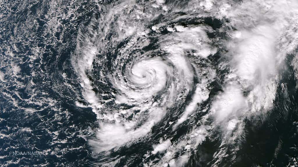
The Atlantic basin has arrived at the statistical peak of hurricane season without producing a single hurricane, an outcome that has not occurred in the reliable satellite record. As of the first week of September, the 2026 season had generated five named tropical storms and zero storms reaching hurricane strength of 74 mph sustained winds. Forecasters describe it as the least active start in at least 60 years.
The National Hurricane Center's tropical weather outlook in the first days of September indicated no tropical cyclone formation expected across the North Atlantic, the Caribbean Sea, and the Gulf for the following seven days. That is an unusual bulletin to issue during the second week of September, which climatologically is the busiest stretch of the entire season.
The absence is approaching a formal record. If no hurricane forms by September 10, the season ties the mark for latest first Atlantic hurricane in the satellite era. If none forms by September 11, the basin enters territory without a modern precedent. In the pre-satellite record, the latest first hurricane of a season formed on October 8, 1905.
Why the basin has stayed quiet
The primary driver appears to be El Nino. The El Nino phase of the El Nino Southern Oscillation cycle warms the eastern tropical Pacific and alters atmospheric circulation across the tropics in ways that suppress Atlantic hurricane development. The dominant mechanism is vertical wind shear, meaning a change in wind speed or direction with height.
Tropical cyclones need a vertically stacked structure to intensify. The warm core has to sit more or less directly above the surface circulation so that the storm's own heat engine can reinforce itself. Strong shear tilts that structure, ventilates the warm core with dry environmental air, and pulls the storm apart faster than it can organize. A basin under persistent shear can produce plenty of tropical waves and even a handful of short-lived named storms without ever letting one reach hurricane strength.
That is a fair description of what the Atlantic has done in 2026. Five named storms formed and none lasted long enough or stayed organized enough to intensify. Forecasters have characterized the season as struggling to generate long-lasting storms at all.
NOAA's seasonal outlook anticipated this. The agency maintained a below-normal forecast heading into the peak, calling for 7 to 13 named storms, 2 to 6 hurricanes, and 0 to 2 major hurricanes, with a 75 percent probability of below-normal activity and only a 5 percent chance of an above-normal season.
What a quiet season does not mean
The most important thing Floridians can understand about a quiet season is that seasonal totals have almost no bearing on individual risk. A season that produces one hurricane can be catastrophic for Florida if that hurricane makes landfall on a populated coastline. A season that produces fifteen can leave the state untouched if every storm recurves into the open Atlantic.
Andrew is the standard illustration. The 1992 season was well below normal in total activity, and the first named storm did not form until mid-August. Andrew was that first storm, and it struck South Florida as a Category 5, killing dozens and causing damage that reshaped the state's building codes and its insurance market for a generation.
The seasonal forecast describes the basin, not any particular stretch of coast. It is a useful tool for reinsurance pricing and for emergency management resource planning. It is close to useless as a guide for whether a given household should have a plan and supplies.
Florida emergency managers have made this point consistently through the 2026 season, and the state's decision to make its disaster supply sales tax exemption permanent rather than confining it to a seasonal holiday reflects the same logic: preparedness should not be keyed to the forecast.
How much season is left
The Atlantic hurricane season runs through November 30, which leaves nearly three months on the calendar. The climatological peak falls around September 10, but the curve does not fall off a cliff afterward. Late September and October remain active periods, and Florida has a particular exposure in October.
Late-season storms in the Atlantic frequently form in the western Caribbean rather than off Africa, and the steering patterns that prevail in October tend to carry those systems north and northeast, directly across Cuba and into the Florida peninsula or the eastern Gulf. Hurricane Wilma in October 2005, Hurricane Michael in October 2018, and Hurricane Milton in October 2024 all followed variations on that pattern.
An El Nino background state suppresses that development too, but suppression is a probability statement rather than a guarantee. Wind shear varies week to week, and a lull of even seven to ten days over the western Caribbean during a period of very warm sea surface temperatures is enough for a system to organize.
Forecasters have been explicit that the quiet start does not clear the basin for the remainder of the season, and the National Hurricane Center continues to issue routine outlooks on its normal schedule.
What it means for Florida
For Florida households, the practical guidance has not changed. Supplies, a written family plan, knowledge of your evacuation zone, and current documentation of your property and insurance coverage remain the same set of tasks they were in June. The absence of storms so far is a reprieve, not a resolution.
Knowing your evacuation zone deserves particular emphasis, because Florida evacuation orders are issued by zone and not by county. A countywide announcement almost never means every resident of that county must leave. County emergency management websites publish zone lookup tools by address, and checking during a quiet week is far easier than checking during a warning.
For Florida's property insurance market, a quiet season is straightforwardly good news. Insurers and reinsurers price for expected loss, and a year without a landfalling hurricane strengthens the case for the rate relief that has already begun to reach Florida policyholders in 2026. Citizens Property Insurance reduced multiperil homeowners rates by an average of 8.8 percent this year, and the private market has followed in most counties.
For coastal businesses, particularly in tourism, a quiet peak season means uninterrupted operations through what is usually the most disruption-prone stretch of the year.
The forecasting picture
A season this far outside the normal range is scientifically interesting in its own right. Seasonal hurricane forecasting has improved substantially over the past two decades, and NOAA's below-normal call for 2026 has verified well so far. Getting the direction right is the basic test of a seasonal forecast, and the agency passed it.
The magnitude is a separate question. A forecast range of 2 to 6 hurricanes with an actual count of zero at the peak means the season is tracking below even the low end of the guidance. That gap is the kind of outcome that drives refinement of the statistical and dynamical models seasonal forecasters use.
Attribution is complicated. El Nino is the obvious candidate and almost certainly the dominant factor, but Saharan dust outbreaks, sea surface temperature patterns in the tropical Atlantic, and the behavior of the Madden-Julian Oscillation all modulate activity on shorter timescales. Sorting out relative contributions is post-season work.
How Florida's risk profile differs by region
Hurricane risk in Florida is not uniform, and the quiet season affects different parts of the state differently in terms of what a late-season storm would mean. South Florida, including Miami-Dade, Broward, and Palm Beach counties, faces the highest exposure to Atlantic systems approaching from the east and southeast, along with the densest concentration of insured property value anywhere in the state.
The Tampa Bay region carries a distinct vulnerability. The bay's shape and the shallow continental shelf offshore can amplify storm surge dramatically for a storm approaching from the right angle, and the region's population has grown substantially in low-lying areas. Emergency managers in Hillsborough, Pinellas, Manatee, and Pasco counties have consistently identified surge, not wind, as the primary threat to life in their evacuation planning.
Southwest Florida absorbed Hurricane Ian in 2022 and remains in recovery, with rebuilt housing stock now meeting current code but with a community memory that shapes how residents respond to warnings. The Panhandle faces Gulf systems that can intensify rapidly over warm water with very little lead time, as Hurricane Michael demonstrated in 2018 when it reached Category 5 intensity before landfall near Mexico Beach.
Northeast and Central Florida are less frequently hit directly but are not exempt. Inland flooding from heavy rainfall reaches communities far from any coast, and Hurricane Helene in 2024 demonstrated how far inland catastrophic freshwater flooding can extend.
Preparedness during a quiet year
The behavioral risk of a quiet season is complacency, and emergency managers are explicit about it. Households that stock supplies in June and never face a threat tend to consume those supplies through the fall, arriving at October with a plan on paper and an empty pantry.
Florida has structured part of its policy response around exactly that problem. The state made its disaster supply sales tax exemption permanent rather than confining it to a limited seasonal holiday window, a change designed to reward steady year-round preparedness rather than a single burst of shopping in late May.
The items that matter most are the ones people forget. Prescription medication supplies, which pharmacies may be unable to refill during an evacuation. Cash, because card systems fail when power and connectivity do. Physical copies of insurance policies and property documentation, which become critical during claims and are useless on a phone with no charge. Photographs of the home's interior and exterior taken before any storm, which substantially strengthen a claim.
Evacuation zone knowledge remains the single highest-value preparation, and it takes minutes. County emergency management websites publish address lookup tools, and the answer does not change from year to year.
What's next
The near-term milestone is September 10 and 11. If the basin remains hurricane-free through those dates, the 2026 season first ties and then breaks the satellite-era record for latest first hurricane.
The National Hurricane Center will continue issuing tropical weather outlooks multiple times daily. Floridians tracking the basin should read those directly rather than relying on secondhand summaries, and should understand the difference between a watch, meaning conditions are possible, and a warning, meaning conditions are expected within 36 hours.
Three months remain in the season, and Florida's most historically dangerous late-season pattern, a western Caribbean system tracking north in October, is still ahead. A record-quiet September is worth noting. It is not worth relaxing about.
Spotted an issue with this article?
Have something to say about this story?
Write us a letterComments
No comments yet. Be the first to weigh in.
Related Coverage
NOAA Winter Outlook Favors a Wet Florida Winter as a Very Strong El Niño Builds
19h ago

Josephine Heads Out to Sea, but Florida's Atlantic Coast Faces Strong Winds, King Tide Flooding and Dangerous Surf This Weekend
3d ago
Strong fall cold front brings Florida Saturday rain, cooler air and dangerous surf this weekend
6d ago

Hurricane Center Gives Atlantic Low Near Cabo Verde a 20% Chance as Florida Gets a Break After Isaias
Oct 12