Heavy Rain and Flood Risk Persist Across South Florida This Week
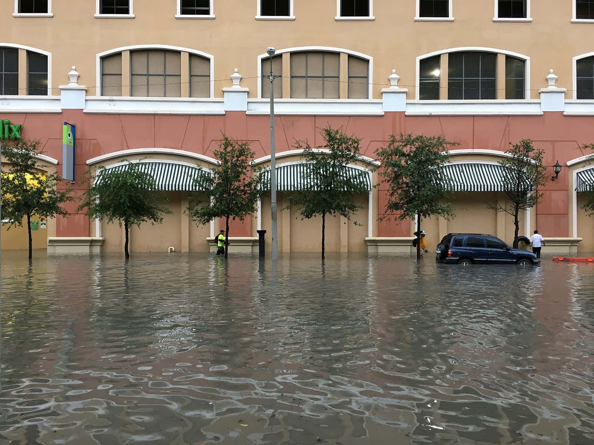
South Florida is working through a stretch of persistent heavy rainfall that has produced localized street flooding and a marginal flash flood risk across much of the southern peninsula, with forecasters expecting the wet pattern to hold through midweek. The setup has nothing to do with a direct tropical threat to Florida. Instead, it is the product of deep tropical moisture, some of it associated with the remnants of Tropical Storm Dolly, interacting with the daily sea breeze convergence that drives South Florida's summer storm cycle. The result has been repeated rounds of downpours falling on ground that has not had time to drain.
The current setup
Forecasters have outlined a Marginal Risk, level 1 of 4 on the excessive rainfall scale, for flash flooding across much of Central and South Florida, with multiple rounds of heavy thunderstorms capable of producing localized flooding and standing water. The greatest exposure is in urban areas and locations with poor drainage, which in South Florida describes a great deal of developed land.
Rainfall totals in the range of 2 to 3 inches have already fallen in some locations, with additional amounts of 1 to 2 inches expected in spots. Those numbers are not extreme in isolation. The problem is the sequencing: repeated rounds falling on saturated ground, in a region where the water table sits close to the surface and where drainage systems are designed around gravity flow into canals that are themselves already carrying water.
Cloud cover and rain have kept temperatures somewhat below the punishing levels typical of a South Florida late summer, which is the one favorable element in the pattern. Heat index values that would ordinarily push into dangerous territory have been moderated by the persistent convection.
Why this floods South Florida
Miami-Dade, Broward and Palm Beach counties sit on flat, low-elevation terrain over porous limestone with a shallow water table. Stormwater management depends on a canal and pump network operated by the South Florida Water Management District along with municipal drainage systems, and the capacity of that network is finite.
When the ground is already saturated, additional rainfall has nowhere to infiltrate. It runs off, and if it runs off faster than the drainage network can move it, it ponds. That is why a 2-inch rainfall in early September can flood streets that handled a 3-inch rainfall in May without difficulty. The antecedent condition matters more than the individual storm total.
Tide state compounds the problem. Drainage in coastal South Florida works by gravity into canals that discharge to tidewater, and at high tide that discharge slows or reverses. Early September falls in a period of higher astronomical tides, which narrows the window during which the system can effectively shed water.
The tropical moisture connection
Moisture associated with the remnants of Tropical Storm Dolly has been feeding into the South Florida pattern, adding precipitable water to an atmosphere that was already primed for convection. A remnant system does not need to be a named storm, or to have a closed circulation, to make a meaningful difference in rainfall efficiency.
Separately, and further west, Tropical Storm Edouard came ashore near Johnson Bayou, Louisiana, with maximum sustained winds near 60 mph, driving heavy rain and flash flooding across southwest Louisiana and southeast Texas. Edouard is not a Florida threat, and its landfall well west of the peninsula means Florida's rain is a locally driven event rather than a storm impact.
That distinction matters for how residents should read the forecast. There is no tropical watch or warning in effect for Florida in connection with this rainfall. What is in effect are flood advisories and localized flood products issued by National Weather Service offices as conditions warrant, and those are the alerts residents should be watching.
What flood advisories actually mean
The National Weather Service issues a graduated set of flood products, and the differences are practical rather than semantic. A flood advisory indicates that flooding is occurring or imminent but is not expected to be severe enough to threaten life or significant property, the category that covers most South Florida street flooding.
A flood watch means conditions are favorable for flooding to develop and is issued in advance. A flood warning means flooding is occurring or imminent and requires action. A flash flood warning is the most urgent of the set, indicating rapid onset flooding that poses immediate danger.
Most of what South Florida experiences in a pattern like this falls into the advisory and localized warning categories. That is not a reason to disregard it. The majority of flood-related deaths in the United States occur in vehicles, and the water depth required to float a passenger car is considerably less than most drivers assume.
What it means for Floridians
The practical guidance is unglamorous and consistent. Do not drive through standing water on roadways, because depth is difficult to judge from a driver's seat and because the roadbed underneath may be compromised. Turn around and find another route, even when the detour is inconvenient.
Residents in low-lying neighborhoods and in areas with known drainage problems should move vehicles to higher ground when heavy rain is forecast, and should keep storm drains near their property clear of debris and yard waste. A single blocked inlet can flood an entire block, and clearing it is often the fastest available intervention.
Commuters across Miami-Dade, Broward and Palm Beach should build in extra time and expect afternoon disruption, since the heaviest convection typically develops in the afternoon and early evening. Standing water on I-95, the Palmetto Expressway and surface arterials produces the compounding delays that turn a 30-minute drive into a 90-minute one.
The seasonal backdrop
September is climatologically the wettest month of the year in much of South Florida, and it is also the peak of Atlantic hurricane season. The overlap is not coincidental. Both reflect the same seasonal maximum in atmospheric moisture and instability over the tropical Atlantic and Caribbean.
That means South Florida residents should treat this rainfall as a routine feature of the season rather than an anomaly, while recognizing that routine does not mean harmless. Chronic wet-season flooding is one of the clearest ways sea level rise expresses itself in South Florida, because higher baseline water levels reduce the drainage capacity available during heavy rain.
Local governments across the region have invested in pump stations, raised roads and drainage improvements in response, with Miami Beach among the most visible examples. Those projects reduce the frequency of nuisance flooding but do not eliminate it, particularly during multi-day rainfall events coinciding with high tides.
How the drainage network works
South Florida's flood control system is one of the largest civil engineering projects in the country, and most residents interact with it daily without knowing it exists. The Central and Southern Florida Flood Control Project, built beginning in the late 1940s after catastrophic flooding, converted a natural sheet-flow landscape into a managed network of canals, levees, water control structures and pump stations.
The system was designed for a South Florida with a fraction of its current population and for sea levels lower than today's. Its design storm assumptions reflect mid-century conditions and mid-century development density, and both have changed substantially. Water managers have been operating an aging system beyond its original parameters for years.
The South Florida Water Management District operates the regional canals and structures, lowering canal levels ahead of forecast heavy rain to create storage capacity. Municipal systems handle local collection and feed into the regional network. When the regional canals are already high, local systems have nowhere to discharge, which is when neighborhood flooding becomes persistent rather than transient.
Sea level rise and the drainage problem
The clearest way rising seas affect South Florida is not through dramatic coastal inundation but through this drainage mechanism. Gravity drainage requires the canal to sit above the receiving water body. As sea level rises, that head differential shrinks, and the window during each tidal cycle when gravity discharge works gets shorter.
Tide gauge records in the region show measurable increases over recent decades, with the rate of rise having accelerated compared with the mid-twentieth century. The practical consequence is that the same rainfall produces more flooding than it did when the system was designed, independent of any change in storm intensity.
Local governments have responded with substantial capital investment: pump stations that force water out when gravity will not, raised roads, upgraded stormwater infrastructure and, in some jurisdictions, revised design standards for new construction. Miami Beach has spent heavily on this and remains the most-studied example. Those projects work, and they are expensive, and they represent a permanent new line in municipal budgets across coastal South Florida.
What's next
The unsettled pattern is expected to persist through midweek, with daily rounds of showers and thunderstorms and a continued risk of localized flooding, particularly in urban and poor-drainage locations. Residents should expect the flood risk to reset each afternoon rather than to resolve after a single day.
Beyond this system, attention across Florida turns to the broader tropics as the Atlantic season reaches its climatological peak around Sept. 10. Forecasters have continued to call for a below-normal season overall, but a below-normal season is a statement about basin-wide totals, not a forecast for any individual storm or any individual coastline.
The near-term action item for South Floridians is simply to stay current with National Weather Service products from the Miami forecast office and with county emergency management channels, and to keep vehicles out of standing water. The pattern will break. Until it does, the risk is manageable and the precautions are ordinary ones.
Spotted an issue with this article?
Have something to say about this story?
Write us a letterComments
No comments yet. Be the first to weigh in.
Related Coverage
Strong fall cold front brings Florida Saturday rain, cooler air and dangerous surf this weekend
2d ago

Hurricane Center Gives Atlantic Low Near Cabo Verde a 20% Chance as Florida Gets a Break After Isaias
5d ago

Tallahassee and the Big Bend Escape Isaias' Worst, With Downed Trees, Brief Outages and Rising Rivers to Watch
Oct 9

Isaias Death Toll Rises to Six as Florida Hits 95% Power Restored and Escambia Tallies $64 Million in Public Costs
Oct 9