Atlantic Sets a Satellite-Era Record With No Hurricanes Through Florida's Peak Season
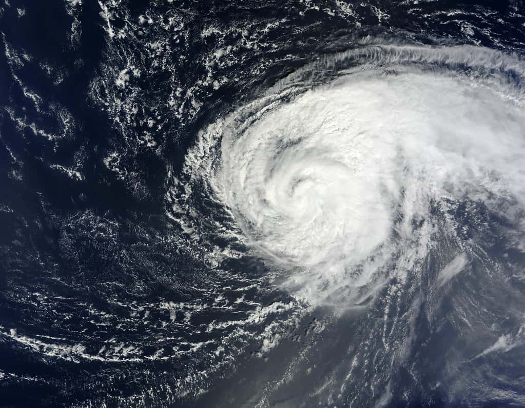
The Atlantic basin has passed the climatological peak of hurricane season without producing a single hurricane, setting a record for the longest stretch without one since the start of modern satellite surveillance in 1966. For Florida, the state most frequently struck by Atlantic hurricanes, the 2026 season has so far been an extraordinary reprieve.
Through mid-September, the season had generated a handful of named tropical storms and zero hurricanes. The previous record for the latest first hurricane of an Atlantic season in the satellite era was September 11, a mark shared by the 2002 and 2013 seasons. The 2026 season moved past that date without one, establishing a new benchmark.
The National Hurricane Center's outlooks through this period have tracked modest, generally low-probability systems. A mid-September outlook described a low pressure area a few hundred miles east of Bermuda in the central subtropical Atlantic, with disorganized showers and thunderstorms and environmental conditions characterized as only marginally conducive for development, carrying formation chances of 20 percent through 48 hours and 30 percent through seven days.
What the numbers look like
NOAA's seasonal outlook for 2026 called for a below-normal Atlantic season, assigning a 55 percent chance to below-normal activity, 35 percent to near-normal, and 10 percent to above-normal. The agency maintained that prediction in its updated outlook as the season progressed.
The updated forecast ranges called for 7 to 13 named storms, of which 2 to 6 could become hurricanes, including 0 to 2 major hurricanes of Category 3 strength or higher. The season's actual performance has tracked toward the low end of those ranges on the hurricane count, though named storm production has continued.
An average Atlantic season, measured over the most recent 30-year climatological period, produces roughly 14 named storms, 7 hurricanes, and 3 major hurricanes. Reaching the second week of September with zero hurricanes is a dramatic departure from that baseline, since in a typical year several would have formed by then.
Why the Atlantic has been so quiet
Forecasters have pointed primarily to El Nino conditions in the Pacific. El Nino is the warm phase of a recurring pattern in the tropical Pacific, and its effects reach the Atlantic through changes in atmospheric circulation, most importantly by increasing vertical wind shear over the Atlantic basin.
Wind shear is the change in wind speed or direction with height. Tropical cyclones require a relatively undisturbed vertical column to organize and intensify, and strong shear tears developing storms apart before they can consolidate a core. A strong El Nino reliably suppresses Atlantic hurricane activity through this mechanism, and the relationship is one of the more robust findings in seasonal hurricane forecasting.
Other factors contribute. Dry, dust-laden air moving off the Sahara can inhibit development in the deep tropics. Sea surface temperature patterns matter, as do the position and strength of the Bermuda high, which steers systems. In 2026 the shear signal appears to have dominated, and the result has been storms that formed and then failed to strengthen.
Why forecasters keep warning against complacency
The consistent message from Florida emergency managers and meteorologists through this quiet season has been that a below-normal season does not mean a safe season, and the historical record supports that position emphatically.
Hurricane Andrew struck South Florida in August 1992 during a season that produced only six named storms and a below-normal overall count. That single storm caused catastrophic damage across Miami-Dade County and reshaped Florida building codes for a generation. The seasonal total was irrelevant to the households that lost everything.
The 2004 season offers a different lesson. As the Pacific transitioned into a weak El Nino, Florida was struck by four hurricanes in a single season. And Hurricane Irma made landfall in the Florida Keys on September 10, 2017, the precise date considered the statistical peak of the season. Seasonal forecasts describe basin-wide activity, not where storms go.
What a seasonal outlook can and cannot tell you
NOAA is explicit on this point: its outlook does not indicate where or when storms may affect land, because landfall is determined by short-term and variable weather patterns rather than by seasonal-scale conditions. The outlook is a statement about basin activity, not a landfall forecast.
The distinction is not academic for Florida. A season producing 20 named storms that all recurve into the open Atlantic is, from a Florida perspective, a quiet season. A season producing eight storms of which one makes landfall near Tampa Bay is, from a Florida perspective, a catastrophe. The seasonal number captures neither outcome.
That is why preparedness guidance in Florida is built around the assumption that any season can produce a landfall, and why the state's emergency management structure operates on the same footing regardless of the seasonal forecast. Households that skip preparation in a quiet year carry the risk of that decision into the one storm that does come.
The season is not over
The Atlantic hurricane season runs through November 30, and while activity typically declines after mid-October, late-season storms are a recognized threat to Florida specifically. Late-season systems often form in the western Caribbean and the Gulf, which puts them closer to Florida with less lead time than storms tracking across the open Atlantic.
Hurricane Wilma, which crossed South Florida in late October 2005, and Hurricane Michael, which struck the Panhandle in October 2018, both demonstrate that October storms can be severe. The Gulf retains substantial heat content into the fall, which supplies the energy a developing system needs.
Florida meteorologists have specifically flagged the Gulf as the area warranting attention for the remainder of this season. A quiet Atlantic does not preclude a Gulf system, and the shorter travel distance means less time for preparation once one forms.
What a quiet season means economically
A season without a Florida landfall has substantial economic consequences that mostly go unremarked because they take the form of costs that do not occur. No debris removal contracts, no emergency housing programs, no state disaster appropriations, and no federal major disaster declarations for wind damage.
For Florida's property insurance market, the implications are significant. The state's insurers have been rebuilding after a difficult period, and Citizens Property Insurance has shed the majority of its policies to private carriers while filing its first statewide rate decrease in about a decade. A loss-free season strengthens carrier balance sheets and supports the case for continued private market participation.
Utilities avoid storm cost recovery surcharges, which are billed to customers after major restoration efforts. Tourism operators avoid the cancellation waves that follow storm coverage even in areas not directly affected. Each of these is a real economic benefit, distributed widely and largely invisibly.
The preparedness infrastructure Florida built
Florida has made hurricane preparedness a permanent feature of state policy rather than a seasonal campaign. The state converted its disaster supply sales tax holidays into year-round exemptions, removing the timing element that previously concentrated purchases into defined windows.
The Florida Division of Emergency Management coordinates with all 67 counties, each of which maintains its own emergency management office and its own evacuation zone structure. Those zones are the operative unit of any evacuation order, which is a point that gets lost in coverage. An evacuation order is issued for specific zones, not for an entire county.
Building codes represent the longest-running investment. Florida's post-Andrew code revisions, and the subsequent statewide code adopted in 2002, produced housing stock that performs measurably better in high winds than what preceded it. Homes built to current code in Florida are among the most wind-resistant residential structures in the country.
Watches versus warnings
Because a quiet season means many Floridians have gone a long stretch without encountering hurricane terminology, a refresher on the basic distinction is worthwhile. A hurricane watch means hurricane conditions are possible within the specified area, typically issued 48 hours in advance of the anticipated onset of tropical storm force winds.
A hurricane warning means hurricane conditions are expected within the specified area, typically issued 36 hours in advance. The difference between possible and expected is the difference between preparing and acting, and it is the single most important distinction in National Hurricane Center products.
Storm surge watches and warnings are issued separately from wind products, because surge is a distinct hazard with distinct geography. Storm surge is the leading cause of death in United States tropical cyclones, and surge risk depends on coastal shape and water depth as much as on storm intensity.
What it means for Floridians
For households, the practical guidance has not changed. A supply kit, a written family plan, knowledge of your evacuation zone, and current insurance documentation are the components, and none of them are season-specific. Flood insurance in particular carries a standard 30-day waiting period, which means it cannot be purchased once a storm is approaching.
For homeowners, the quiet season is an opportunity to address deferred items: roof inspections, shutter hardware, tree trimming, and generator maintenance are all easier to handle without a deadline. Contractors are available and materials are in stock in a way they are not once a storm has been named.
For renters, the flood coverage gap is particularly acute. Standard renters insurance does not cover flood damage to personal property, and contents coverage through the National Flood Insurance Program is available to renters independently of the building owner's coverage.
Local impact across the state
Southwest Florida has the most recent and most severe storm history among the state's major regions, and communities from Fort Myers through Naples continue working through recovery and rebuilding from prior seasons. A year without additional damage allows that work to advance rather than restart.
The Tampa Bay region carries the state's most frequently discussed surge vulnerability, given the shallow shelf and the bay's geometry, which can amplify surge substantially in the wrong storm track. Pinellas County's zone-based evacuation structure is designed around that exposure.
The Panhandle, the Keys, and the Treasure Coast each carry distinct risk profiles shaped by geography and construction age. The Keys in particular have limited evacuation routes, which is why orders there are issued earlier than elsewhere in the state.
What's next
The National Hurricane Center issues tropical weather outlooks multiple times daily throughout the season, and those products remain the authoritative source for current conditions. Floridians tracking the tropics should rely on the Hurricane Center directly rather than on aggregated forecasts.
The season continues through November 30, with the western Caribbean and Gulf representing the areas of greatest late-season concern for Florida. Whether 2026 produces its first hurricane at all remains an open question, and if one forms, it will do so in a basin that has been actively hostile to development all year.
For emergency managers, the bigger concern is what a quiet year does to public readiness heading into 2027. Preparedness erodes when nothing happens, and the seasons following quiet ones have historically found Florida households less ready than the seasons following active ones.
Spotted an issue with this article?
Have something to say about this story?
Write us a letterComments
No comments yet. Be the first to weigh in.
Related Coverage

Storm-Force Low Off Southeast Coast Has 40% Chance to Turn Subtropical as Florida Coast Faces Tidal Flooding, Rough Surf
1d ago
Strong fall cold front brings Florida Saturday rain, cooler air and dangerous surf this weekend
4d ago

Hurricane Center Gives Atlantic Low Near Cabo Verde a 20% Chance as Florida Gets a Break After Isaias
Oct 12

Tallahassee and the Big Bend Escape Isaias' Worst, With Downed Trees, Brief Outages and Rising Rivers to Watch
Oct 9