Daily Downpours Soak Florida as Flood Advisories Stack Up Across the State
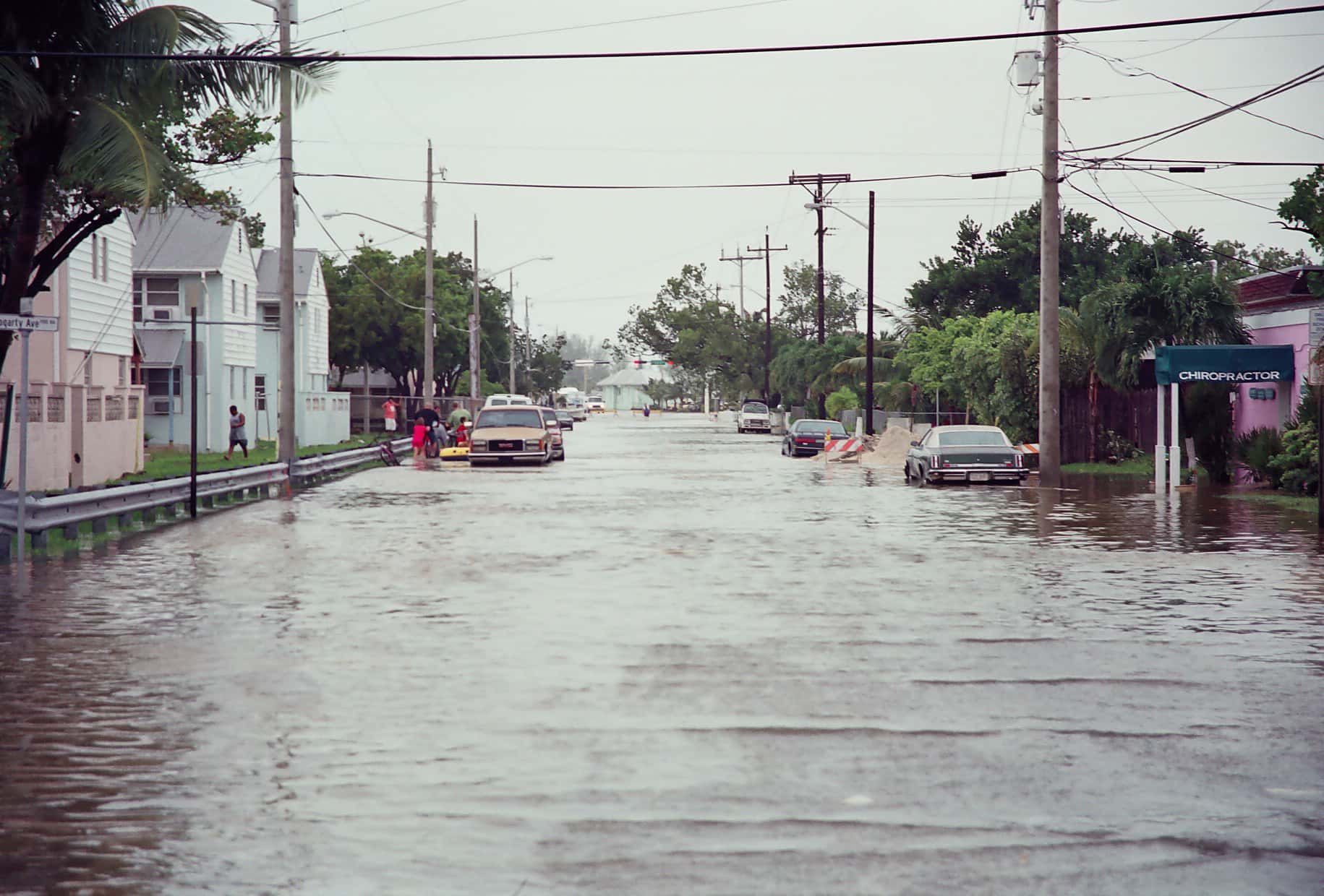
Florida is working through a soaking stretch of weather that has little to do with the tropics and everything to do with a stalled, moisture-rich pattern parked over the peninsula. The National Weather Service issued a string of flood advisories on Sunday covering Central Florida communities including Orlando, Apopka, Altamonte Springs, Ocoee, Winter Garden, Winter Park and Eustis, along with northern Miami-Dade County areas including Hialeah, Miami Gardens, Miami Lakes and Opa-locka. Rainfall totals of one to three inches were reported in some locations, with additional amounts of up to an inch and a half expected on top of already saturated ground. Forecasters expect daily rounds of showers and thunderstorms to continue across much of the state through the week.
What is driving the pattern
Early September in Florida is climatologically the wettest part of the year. The peninsula sits under deep tropical moisture, sea breeze boundaries collide from both coasts each afternoon, and daytime heating provides the lift that turns that moisture into thunderstorms.
What separates a routine wet week from a flooding week is steering flow. When upper-level winds are weak, storms move slowly or barely at all. A thunderstorm capable of producing two inches of rain per hour is a nuisance if it moves at 25 miles per hour and a flooding threat if it crawls.
That is the situation Florida has been in. Forecasters have described the storms as slow-moving and capable of dropping excessive rain in a short period, which is the specific ingredient that produces urban and small-stream flooding rather than simply a wet afternoon.
None of this activity is tropical in origin. The National Hurricane Center is not tracking any system expected to develop in the Atlantic basin over the next seven days. This is a homegrown pattern.
Where the flooding has been worst
The Orlando metropolitan area drew multiple advisories. Central Florida's drainage is heavily dependent on retention ponds, lakes and permeable soil, and when the water table rises after consecutive days of rain, that system loses capacity quickly. Streets in low-lying subdivisions flood not because a river overtopped its banks but because the ground can no longer absorb anything.
Northern Miami-Dade County saw a similar sequence. Hialeah, Miami Gardens, Miami Lakes and Opa-locka sit on flat terrain with limited elevation change, and South Florida's canal system relies on gravity flow that becomes less effective when regional water levels are already high.
Inland, the Fisheating Creek gauge at Palmdale in Glades County was expected to remain at action stage, meaning bank-full conditions, into the early part of the week. Action stage is the lowest of the formal flood categories and indicates that officials should begin monitoring, not that widespread flooding is underway.
Special weather statements were also issued in various parts of the state, covering short-duration threats from individual storm cells including gusty winds and frequent lightning.
Understanding the advisory levels
The National Weather Service uses a tiered system that is worth knowing, because the words carry specific meanings. A flood advisory indicates that flooding is occurring or imminent but is not expected to be severe enough to threaten life or cause major property damage. It typically covers nuisance flooding of roads, underpasses and low-lying areas.
A flood watch means conditions are favorable for flooding to develop but it has not yet occurred. A flood warning means flooding is occurring or imminent and is expected to be significant. A flash flood warning is the most urgent category, indicating rapid onset flooding that poses an immediate danger.
The distinction between watch and warning applies across weather hazards in the same way. A watch means be prepared. A warning means take action now.
Most of what Florida has seen this week falls in the advisory category, which is the least severe tier. That does not make it harmless. Roadway flooding is the leading cause of weather-related deaths in many years, and the depth of standing water is routinely underestimated by drivers.
Driving and safety guidance
The standing advice from emergency managers is short and consistent: turn around, do not drown. Six inches of moving water can knock an adult off their feet. Twelve inches can float most passenger vehicles. Two feet will carry away nearly anything on the road, including trucks and SUVs.
Road surfaces beneath standing water may be washed out or collapsed, and water depth is nearly impossible to judge from a driver's seat at night. Florida's flat topography makes this particularly deceptive, because a road that looks passable can drop several inches over a short distance.
Lightning is the other under-appreciated hazard. Florida leads the nation in lightning strikes and lightning fatalities, and the afternoon thunderstorm season is when that risk concentrates. The guidance is to move indoors at the first thunder and to wait 30 minutes after the last thunder before returning outside.
Drivers should also allow extra time. Wet pavement after a dry spell is at its most slippery in the first minutes of rain, when accumulated oil lifts off the surface.
The infrastructure question
Repeated flooding weeks reopen a longstanding conversation about Florida's stormwater infrastructure. Much of the drainage in older Florida communities was engineered decades ago for rainfall intensities that current data no longer supports.
Local governments across the state have been steadily upgrading pump stations, enlarging retention capacity and raising road grades in flood-prone corridors, often funded through stormwater utility fees and state resilience grants. Miami Beach, Fort Lauderdale, Tampa and St. Petersburg have all undertaken substantial projects.
Those upgrades are expensive and slow. A single pump station can cost tens of millions of dollars, and the work usually requires tearing up streets in developed neighborhoods. Progress is measured in decades rather than seasons.
Development pressure works in the opposite direction. Every acre converted from pasture or wetland to rooftops and pavement reduces the landscape's ability to absorb rainfall, pushing more water into engineered systems. Florida's growth rate makes that a continuous constraint rather than a solved problem.
What it means for the rest of the week
Forecasters expect the unsettled pattern to persist, with daily rounds of showers and thunderstorms across much of the peninsula. Rain chances are highest in the afternoon and evening, following the usual sea breeze timing, though morning activity has been occurring as well in the wetter pattern.
Ground saturation is the compounding factor. Each successive day of rain falls on soil with less remaining capacity, which means the same rainfall total produces more runoff on Wednesday than it did on Sunday. That is why flood advisories tend to cluster later in a wet stretch.
Residents in flood-prone areas should check that yard drains and gutters are clear, move vehicles to higher ground where possible, and keep an eye on county emergency management alerts. Most Florida counties operate opt-in notification systems that deliver targeted alerts by text or phone.
Homeowners should also be aware that standard homeowners insurance does not cover flood damage from rising water. That coverage requires a separate flood policy, which carries a waiting period before it takes effect.
Why September is Florida's wettest month
Florida receives the bulk of its annual rainfall between June and September, and September typically records the highest totals. The peninsula sits in a subtropical regime where warm surface waters on three sides feed a nearly continuous supply of atmospheric moisture.
The daily mechanism is the sea breeze. As land heats faster than water, air rises over the interior and is replaced by inflow from both coasts. Where the two sea breeze boundaries collide, usually over the interior in the afternoon, the resulting lift produces thunderstorms almost daily during the warm season.
The position of that collision shifts with the prevailing wind. An easterly flow pushes the boundary toward the Gulf coast, and a westerly flow pushes it toward the Atlantic coast. That is why storms cluster on one side of the state on some days and the other side on others.
Adding tropical moisture to that baseline, as has happened this week, raises rainfall efficiency substantially. The same storm produces more rain when the atmospheric column holds more water.
Insurance and the flood coverage gap
The most expensive misunderstanding in Florida homeownership is the belief that homeowners insurance covers flooding. It does not. Standard policies exclude damage from rising surface water, which is precisely the mechanism at work in this week's advisories.
Flood coverage comes through the National Flood Insurance Program or through a growing private flood market. Policies generally carry a 30-day waiting period before taking effect, which means coverage cannot be purchased in response to an approaching threat.
A large share of Florida flood damage occurs outside designated high-risk flood zones. Lenders require flood insurance only inside those zones, which leaves many homeowners uninsured against a risk they actually face. Nationally, a substantial fraction of flood claims come from properties outside mapped high-risk areas.
Renters have a parallel gap. Renters insurance covers personal property against many perils but not flood, and a separate contents-only flood policy is available for those who want it.
What's next
The pattern will eventually break when steering flow strengthens or drier air works into the peninsula. Until then, the daily routine of afternoon storms and localized flooding is likely to continue.
The broader seasonal picture remains favorable. With the Atlantic basin quiet and no tropical development expected in the near term, Florida's water problem this week is rainfall rather than surge. That is a meaningfully better situation than the alternative.
Residents can track conditions through their local National Weather Service office, which for Florida means the Miami, Tampa Bay, Melbourne, Jacksonville, Tallahassee and Key West forecast offices, each covering a defined county area. Advisories are issued at that local level rather than statewide.
The Florida Division of Emergency Management maintains a statewide weather page as well, and county emergency management offices remain the authoritative source for local road closures and shelter information.
Spotted an issue with this article?
Have something to say about this story?
Write us a letterComments
No comments yet. Be the first to weigh in.
Related Coverage
NOAA Winter Outlook Favors a Wet Florida Winter as a Very Strong El Niño Builds
1d ago

Josephine Heads Out to Sea, but Florida's Atlantic Coast Faces Strong Winds, King Tide Flooding and Dangerous Surf This Weekend
4d ago
Strong fall cold front brings Florida Saturday rain, cooler air and dangerous surf this weekend
Oct 15

Hurricane Center Gives Atlantic Low Near Cabo Verde a 20% Chance as Florida Gets a Break After Isaias
Oct 12