Extreme Drought Vanishes From Florida Map After a Week of Rain
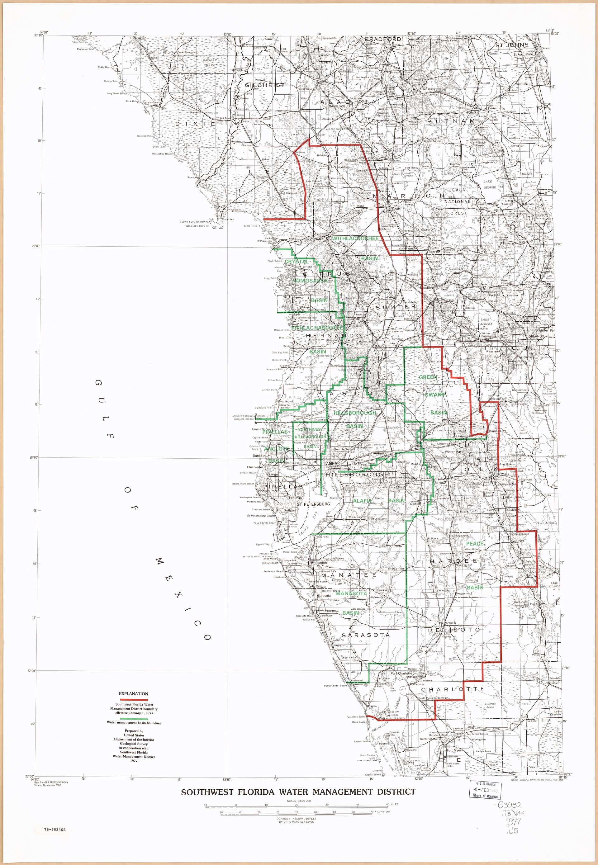
Florida's drought eased sharply in a single week. The U.S. Drought Monitor released Thursday, Oct. 15, showed that the extreme drought pockets that had lingered in west-central and north-central Florida were gone from the map, and that severe drought coverage had shrunk significantly, according to a comparison of the Oct. 6 and Oct. 13 maps reported by Florida public radio.
The improvement follows weeks of heavier rain around Tampa Bay and a wet stretch across North Florida. But dry conditions remain widespread on the peninsula, groundwater is still low, and regional watering restrictions in the Tampa Bay area remain in effect through March.
What changed this week
The Drought Monitor, a weekly map produced by federal agencies and the National Drought Mitigation Center, ranks conditions from abnormally dry (D0) through moderate (D1), severe (D2), extreme (D3) and exceptional (D4) drought. The maps are valid each Tuesday and released Thursday.
The biggest change came in west-central Florida, including parts of the Tampa Bay region and nearby inland communities. In its drought statement for the Oct. 6 map, the National Weather Service in Tampa Bay listed extreme drought in southern Pinellas, southwestern Hillsborough, western and northern Manatee, southeastern Hardee, northeastern DeSoto and southwestern Highlands counties, with severe drought across much of the rest of the area. By Oct. 13 the extreme drought was gone and much of the region had moved to moderate drought or abnormally dry.
The table below summarizes the shift by region, based on the Drought Monitor maps as described by Florida public radio and the weather service.
| Region | Oct. 6 map | Oct. 13 map |
|---|---|---|
| West-central Florida and Tampa Bay | Severe drought, extreme pockets near the coast and inland | No extreme drought; mostly moderate drought or abnormally dry |
| North-central Florida | An area of extreme drought | Extreme drought gone, replaced by lesser categories |
| Lake Okeechobee region | Severe drought | Improved one category, to moderate drought |
| Panhandle and parts of the Atlantic Coast | Largely drought free | Largely drought free |
Not everything improved. Much of Central Florida remains abnormally dry, with moderate drought across parts of the interior peninsula, and portions of Southwest and South Florida are still in moderate drought. In South Florida, the National Weather Service in Miami said in its Oct. 15 update that severe drought persists from the western Everglades of Miami-Dade County into mainland Monroe County, while the rest of the region saw only isolated showers and little change. The wet season left uneven totals there: from May 1 through Oct. 14, Miami International Airport recorded 28.91 inches of rain, 19.28 inches below normal, while Fort Lauderdale-Hollywood International recorded 41.65 inches, slightly above normal, according to the Miami office.
Where the rain came from
Around Tampa Bay, the turnaround has been building since late summer. River flows "have really picked up with rain since late August," Warren Hogg, chief science officer at Tampa Bay Water, told WUSF this week.
In the Panhandle, Hurricane Isaias made landfall near Destin on Oct. 9 as a Category 2 storm with 105 mph winds. Its own rainfall was relatively limited because of dry air and the storm's fast movement, with most reporting sites recording 2 to 6 inches. But a stalled front had already been soaking the region for days, and with both systems combined many locations reported 10 to 20 inches of rain.
Around Lake Okeechobee, heavy rain over South Central Florida has started sending water into the lake from the Kissimmee River, raising the lake and easing drought nearby, the Miami weather service office said.
Tampa Bay's water supply
The rain has made a visible difference in the region's main reservoir. The C.W. Bill Young Regional Reservoir, which supplies Hillsborough, Pinellas and Pasco counties, held about 5.5 billion gallons a month ago, Hogg said. It is now at about 11.2 billion gallons, roughly 72% full. The weather service had put the reservoir at 10.39 billion gallons on Oct. 8, about 67% of its 15.5 billion gallon capacity.
Underground supplies have been slower to recover. In its Oct. 9 drought statement, the Tampa Bay weather service office said surface water and groundwater levels across the area remained lower than normal for the time of year, with aquifer levels around the 20th percentile.
The Southwest Florida Water Management District declared a Modified Phase III "Extreme" Water Shortage on March 1, citing rainfall and river flow deficits and projected low reservoir levels. On Sept. 22, the district extended the watering restrictions through March 31, 2027. Local governments are enforcing them; Tampa, for example, has fines of up to $500 and a mandatory court appearance for violators.
Hogg said the district looks at lake, wetland, aquifer and river levels as well as public supply systems, and "if conditions improve, that could be changed." He also urged residents to keep conserving. "When you have a watering day, you water on your day only if you need to," he said. "It's not a requirement."
A long drought, now easing
The improvement caps a difficult year. In late March, about 9% of Florida was in exceptional drought, the most severe category, with the worst conditions along the Interstate 10 corridor in North Florida. Florida public radio reported at the time that it was the worst drought the state had experienced since Drought Monitor records began in 2000, with many regions running rainfall deficits of more than a foot. The Tampa Bay region has faced a depleted water supply for two consecutive summers.
The swing from drought to heavy rain has had side effects. Mosquito control experts say this year's extreme drought along the Gulf Coast followed by heavy rain in August contributed to a surge in mosquitoes and the Tampa Bay dengue outbreak.
What's next
Florida is heading into its typically drier months, when rain becomes less frequent, so further gains will depend on how much rain falls this fall and winter. A strong cold front is expected to bring rain on Saturday and cooler air this weekend.
The longer outlook is more encouraging. El Niño is likely to persist through the winter, a pattern that typically steers storm systems farther south and brings more cold fronts to Florida, making a cooler and wetter season than average more likely. The next Drought Monitor update is due Thursday, Oct. 22.
Spotted an issue with this article?
Have something to say about this story?
Write us a letterComments
No comments yet. Be the first to weigh in.
Related Coverage

Record Sargassum Season Fades as Key West and UM Researchers Prepare for the Next Wave
4d ago
Florida's New Stormwater Pollution Credit Rules Draw Fire From Environmentalists and Industry Alike
6d ago
Lead pellets from shot iguanas linked to first known crocodile poisoning death in Florida
Oct 7

DeSantis and Cabinet protect more than 10,770 acres, from Putnam County woods to Martin County ranches
Oct 4