NOAA Forecasts a Below-Normal Hurricane Season, but Florida Officials Urge Preparation Anyway
Federal forecasters are predicting a below-normal 2026 Atlantic hurricane season, a forecast that offers cautious optimism but comes with a familiar warning from Florida emergency officials: a quiet outlook does not guarantee a quiet year. The National Oceanic and Atmospheric Administration's outlook reflects conditions expected to suppress storm activity, even as the season's first storm has already soaked the Gulf Coast.
NOAA's outlook gives the highest probability to a below-normal season, with smaller chances of near-normal or above-normal activity. The forecast is shaped by the expected development of El Nino conditions, which tend to inhibit Atlantic hurricane formation, even as ocean temperatures remain slightly warmer than normal.
For Florida, the most hurricane-exposed state in the nation, the forecast is a reminder that seasonal outlooks describe overall activity, not the risk to any particular place. State officials consistently emphasize that it takes only one storm to make a season catastrophic for the communities in its path, a lesson the state has learned repeatedly across its history.
What the forecast says
NOAA's outlook indicates a greater likelihood of below-normal activity for the 2026 season, with lower probabilities assigned to near-normal or above-normal outcomes. The forecast reflects the agency's assessment of the large-scale climate factors that influence storm formation across the basin over the course of a season.
A key driver is the anticipated development and intensification of El Nino, a climate pattern associated with conditions that tend to suppress Atlantic hurricane activity. El Nino can increase wind shear over the Atlantic, which disrupts the formation and strengthening of tropical systems by tearing apart the organized structure storms need to grow.
At the same time, forecasters note that ocean temperatures in the Atlantic are expected to be slightly warmer than normal, a factor that can support storm development. Warm water serves as fuel for tropical systems, and its presence means that any storms that do overcome the suppressing influence of wind shear could still find conditions favorable for strengthening.
The interplay of these competing influences produces the overall expectation of a below-normal but not inactive season. That tension between a suppressing climate pattern and supportive ocean temperatures is precisely why forecasters caution against reading a below-normal outlook as a forecast of safety. The factors that shape a season operate across the basin and over months, while the danger to any community comes down to the path of individual storms.
Why a forecast is not a guarantee
Seasonal forecasts describe the expected overall level of activity across the entire Atlantic basin, not where storms will strike or how intense any individual storm will be. A below-normal season can still produce a devastating hurricane that makes landfall in a populated area, and the basinwide count offers no assurance to any single community.
Florida's history is full of examples in which a single storm defined a season for the communities it hit, regardless of the basinwide totals. The state's emergency managers stress that residents should prepare every year as if a major storm could threaten them, because the seasonal outlook offers no protection at the local level. A season that produces few storms can still be remembered as catastrophic by the towns that lie in the path of the one that strikes.
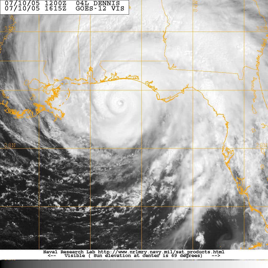
The season's first named storm, which soaked the Gulf Coast and brought a high flood risk to the Florida Panhandle, illustrated the point early. Even in a season forecast to be below normal, dangerous weather can arrive, reinforcing the need for vigilance from the start. The early activity served as a concrete reminder that the statistical expectations of a forecast do not translate into calm conditions on the ground.
Forecasters also caution that seasonal outlooks carry inherent uncertainty, as the climate patterns that shape them can shift over the course of months. An outlook issued before the season's peak is a snapshot of expected conditions, not a fixed prediction, and the agencies that produce these forecasts update them as the season unfolds and new data become available.
The Florida context
Florida is uniquely vulnerable to hurricanes, with extensive coastline, a dense and growing population, and a history of destructive storms. The state has absorbed major hurricanes in recent years, leaving communities acutely aware of the threat and the importance of preparation. The combination of low-lying terrain, exposure on multiple coasts, and rapid development in vulnerable areas heightens the stakes each season.
The state maintains a robust emergency-management apparatus built around the annual threat, coordinating with federal agencies, local governments, and utilities. That infrastructure is activated each season regardless of the forecast, ready to respond to whatever storms develop. Years of experience with major storms have shaped a system designed to move quickly when a threat materializes, from evacuation orders to the staging of recovery resources.
Preparation in Florida is a year-round and especially a season-long endeavor, encompassing evacuation planning, supply stockpiling, and public education. The state's leaders use the start of each season to remind residents to ready themselves, a message that holds even when the outlook is favorable. That steady drumbeat of preparedness messaging reflects an understanding that the cost of complacency can be measured in lives.
The state's continued population growth adds urgency to that message, as each season brings new residents who may never have experienced a major storm. For those arriving from regions unaccustomed to hurricanes, the routines that longtime Floridians take for granted, from knowing an evacuation zone to maintaining a supply kit, may be unfamiliar, making public education an enduring priority.
Development patterns compound the challenge, as growth has pushed homes and communities into areas exposed to wind and water. More people and more property in harm's way mean that even a single storm can inflict greater losses than it might have in decades past. That reality lends weight to the preparedness message, since the potential consequences of a major landfall have grown alongside the state's population and its built environment.
Updated forecast tools
Ahead of the season, the National Hurricane Center announced updates to its forecast products designed to better communicate risk to the public. Among the changes, the forecast cone will now display inland tropical storm and hurricane watches and warnings, extending the visual representation of risk beyond the coast.
That update reflects a growing emphasis on conveying inland threats, including flooding, which often proves the deadliest aspect of tropical systems. By showing inland watches and warnings, forecasters aim to help residents away from the coast understand the dangers they face, countering a common perception that hurricane risk ends at the shoreline.
Improved communication tools are part of a broader effort to ensure that the public responds appropriately to storm threats. Clearer messaging about risks, including the distinction between watches and warnings and the dangers of inland flooding, can save lives when storms approach. The forecast cone has long been one of the most widely viewed products during a storm, and refining it carries the potential to reach a broad audience.
The emphasis on inland flooding addresses a persistent challenge in storm communication, as the wind speeds that define a hurricane's category do not capture the full scope of its danger. Water, from storm surge along the coast to freshwater flooding far inland, has historically accounted for much of the loss of life in tropical systems, and the updated tools seek to bring that risk into sharper focus.
The challenge of communicating risk is heightened by the way many residents interpret a storm's category as a simple measure of how much to worry. A lower-category storm can still produce catastrophic flooding, and a system's slow movement or heavy rainfall can prove as dangerous as its peak winds. Forecasters have worked to convey that the threats posed by a tropical system are varied and that residents should weigh the full range of hazards rather than fixating on a single number.
What it means for residents
For Florida residents, the central message is to prepare regardless of the seasonal forecast. Having a hurricane plan, an emergency supply kit, and a reliable way to receive alerts are essential steps that should be completed early in the season, before any threat emerges to complicate the process.
Residents are encouraged to know their evacuation zone, understand their home's vulnerability to wind and flooding, and review their insurance coverage before a storm threatens. Taking these steps in advance avoids the scramble that occurs when a hurricane is bearing down, when supplies grow scarce and roads fill with traffic. Reviewing insurance in particular can prevent costly surprises, as some forms of coverage carry waiting periods or specific requirements.
The below-normal forecast should not breed complacency, officials warn, because the risk to any individual community depends on the path of storms that do form. Preparation remains the most effective protection, and it is most valuable when undertaken before a threat materializes. The discipline of preparing every season, regardless of the outlook, is what allows communities to respond effectively when a storm does arrive.
Preparation also extends to planning for the aftermath, which can prove as challenging as the storm itself. Extended power outages, disrupted supply lines, and damaged infrastructure can follow a major hurricane, and households that plan for those conditions are better positioned to weather the recovery. Officials encourage residents to think beyond the moment of landfall, considering how they will manage in the days or weeks that may pass before normal services are restored.
What's next
The hurricane season runs through November, with activity typically peaking from August through October. Forecasters will continue to monitor the tropics and update their assessments as the season progresses and as climate conditions evolve, refining their outlook as the peak months approach.
Florida's emergency managers will remain on alert throughout the season, ready to respond to any storms that develop and threaten the state. The early activity in the Gulf serves as a reminder that the season is underway and that preparation cannot wait for the statistical peak to arrive.
For now, the below-normal forecast offers a measure of cautious optimism, tempered by the recognition that a single storm can change everything. Florida residents are urged to use the season's start to finalize their preparations and stay informed as the months ahead unfold, treating the forecast as context rather than reassurance.
Spotted an issue with this article?
Have something to say about this story?
Write a letter to the editor