Florida Wildfires and Historic Drought Ease as Late-May Rains Arrive
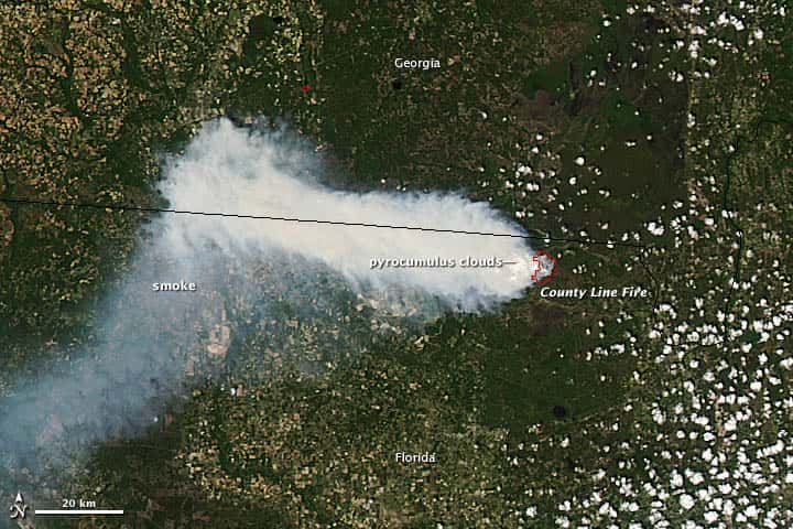
Florida is beginning to see relief from one of its worst droughts in decades, as late-May rains move across the peninsula after months of bone-dry conditions that fueled more than 2,000 wildfires and burned roughly 135,000 acres since January. Forecasters caution that scattered storms will not erase a rainfall deficit built up over the better part of a year, but the return of regular afternoon thunderstorms marks an important turn as the state heads toward the June 1 start of hurricane season. The drought has tested firefighters, farmers and water managers across multiple regions of the state.
How severe the drought became
By the depths of the dry spell, more than half of Florida was classified in extreme drought by the U.S. Drought Monitor, with roughly 22 percent of the state reaching the most severe exceptional drought category. Earlier in the year, nearly the entire state was in some level of drought, an unusually broad and intense pattern for the peninsula.
A major driver was the quiet 2025 Atlantic hurricane season, which delivered few of the landfalling systems that normally soak Florida during the summer and fall. Without those tropical rains, soil moisture and water levels fell sharply, leaving vegetation parched and primed to burn heading into the spring.
The result was a tinderbox stretching across the Southeast, with Florida among the hardest-hit states. Dry air, gusty winds and abundant dead fuel combined to let fires spread quickly once they sparked, straining firefighting resources during what is historically the most active stretch of the year.
The intensity of the drought was notable even by the standards of a state accustomed to a pronounced dry season. The combination of a rainfall shortfall stretching back many months and the absence of tropical moisture created conditions that land managers described as among the most challenging in recent memory.
The toll of the fire season
State officials reported that more than 2,000 wildfires had ignited since January, scorching roughly 135,000 acres. The most active months for Florida wildfires are typically April, May and June, and this year's drought amplified both the number and intensity of blazes.
The fires prompted evacuation orders in parts of the state and forced crews to mount sustained responses across rural and wildland-urban interface areas where homes border forests and brush. Smoke from the blazes degraded air quality at times and posed hazards on highways where visibility dropped.
Prescribed burns, a key tool that land managers use to reduce fuel loads, became harder to conduct safely amid the extreme conditions, complicating long-term fire management. The combination of natural ignitions and dangerous burning conditions kept agencies on high alert for months.
Firefighting crews from state and local agencies worked extended stretches to contain blazes that flared across the peninsula and Panhandle. The sustained effort drew on resources from across Florida as agencies coordinated responses to fires that could grow rapidly in the dry, windy conditions.
The Florida context
Florida's wet and dry seasons drive a familiar annual rhythm, with a dry winter and spring giving way to a rainy summer. This year, the dry season ran deeper and longer than usual, leaving the state far behind on rainfall as the calendar pushed toward the typical onset of summer storms.
The drought carried implications well beyond fire risk. Low water levels stressed agriculture, lawns and landscaping, and raised concerns about water supply in some areas. It also intersected with the approach of hurricane season, since parched ground and stressed vegetation respond differently to a sudden influx of tropical moisture.
Water managers across the state's regional districts monitored conditions closely, balancing the need to conserve supplies during the shortage against the prospect of heavy rain returning. The transition from drought to the wet season is rarely smooth, and the swing can bring its own hazards.
The drought also raised questions for the upcoming hurricane season, as scientists study how dry land conditions interact with tropical systems. A parched landscape can struggle to absorb the intense rainfall that storms deliver, a dynamic that emergency managers factor into their planning.
The turn toward wetter weather
In late May, moisture levels began climbing across the peninsula, bringing the scattered afternoon thunderstorms that are typical of late spring and early summer in Florida. One recent day brought widespread heavy rain and storms across much of the state, a welcome sight after the long dry stretch.
Forecasters emphasized that isolated storms, while beneficial, will not immediately reverse months of accumulated rainfall deficits. Long-term recovery, they cautioned, will likely require weeks or even months of consistent rain to fully replenish soil moisture, water bodies and aquifer levels.
The gradual increase in rainfall does lower the immediate wildfire threat in areas that receive significant precipitation, even as the broader drought lingers. The pattern is expected to continue building as the wet season establishes itself across the state.
The timing of the wet-season onset is closely watched each year, since it marks the transition from peak fire danger to the rainier months. This year, the arrival of regular storms offered a measure of relief just as the state prepared for the start of hurricane season.
What it means for Floridians
For residents, the return of rain reduces the near-term danger of fast-moving wildfires and improves conditions for lawns, gardens and agriculture that suffered through the dry months. It also helps clear the smoky skies that periodically settled over fire-affected areas.
At the same time, the swing from drought to a potentially active wet season carries its own risks. Hardened, dry ground can shed heavy rain rather than absorb it, raising the chance of localized flooding when intense storms arrive. Residents in low-lying areas should remain mindful of that hazard as rainfall ramps up.
The timing also matters for hurricane preparedness. With the season opening June 1, the same atmospheric moisture that ends the drought can feed tropical systems, making the transition period a critical window for households to ready their emergency plans.
Homeowners and businesses that endured months of dry conditions will welcome the rain, but officials urge residents to stay alert to the changing hazards. The shift from fire danger to flood risk requires a corresponding shift in preparedness as the season turns.
Local impact across the state
The drought and fire risk were not uniform across Florida. Inland and rural areas with abundant wildland were especially vulnerable to fast-spreading fires, while the agricultural heartland felt the strain of dry soil on crops and pasture. Coastal and urban areas faced smoke and air-quality concerns when nearby blazes flared.
As rains return, the benefits are likewise uneven, with some regions receiving heavy downpours while others wait longer for meaningful relief. Land managers in fire-prone districts will continue to watch conditions even as the overall threat eases.
Agricultural communities across the interior of the state stand to gain the most from sustained rainfall, which can help recover stressed crops and replenish irrigation sources. The full picture of the drought's impact on Florida agriculture will come into focus as the wet season progresses.
Communities in the wildland-urban interface, where development meets forests and brush, remain particularly attentive to fire risk during any dry breaks. The patchwork of conditions across Florida means preparedness needs vary from region to region even as the statewide outlook improves.
Effects on water and wildlife
The drought's effects extended beyond fire risk to the state's water systems and natural habitats. Low water levels stressed wetlands, lakes and rivers, and raised concerns about the aquifers that supply much of Florida's drinking water. Prolonged dryness can also concentrate pollutants and stress aquatic life.
Wildlife felt the strain as well, with reduced water availability affecting habitats across the state. Florida's natural areas, from the Everglades to inland forests, depend on seasonal rainfall to maintain the conditions that sustain their ecosystems.
The return of rain begins to ease those pressures, replenishing water bodies and supporting the habitats that suffered through the dry months. But as with soil moisture, full recovery of water systems takes time and sustained precipitation.
Water managers will continue to monitor levels as the wet season progresses, balancing the recovery from drought against the potential for heavy rain to cause localized flooding. The transition period requires careful management of the state's water resources.
The drought also affected agriculture across the state, stressing crops and pasture and raising costs for growers who had to irrigate more heavily or contend with reduced yields. Florida's agricultural sector, a major part of the rural economy, felt the strain of the prolonged dry conditions.
As rains return, growers will be watching to see whether the recovery is sufficient to ease those pressures. The transition to the wet season offers hope for relief, though the full impact of the drought on the year's harvests will take time to assess.
What is next
Meteorologists expect the wet-season pattern to strengthen through June, gradually chipping away at the rainfall deficit if storms become more frequent and widespread. A return to regular tropical moisture would mark a decisive end to the drought, though officials stress that recovery will take time.
Fire agencies will remain watchful during any dry breaks between storms, since pockets of drought can persist even as overall conditions improve. Residents are encouraged to heed any burn bans or restrictions that remain in place in their areas.
The bigger wildcard is the hurricane season itself. The same rains that relieve the drought could intensify if the tropics become active, turning a welcome recovery into a different kind of weather challenge. For now, Floridians are watching the skies with a mix of relief and caution as the state's long dry spell finally loosens its grip.
The coming weeks will reveal whether the rains hold and the drought continues to recede, or whether dry conditions linger in pockets of the state. Either way, the transition underscores the volatility of Florida weather and the importance of staying prepared as the seasons shift.
Spotted an issue with this article?
Have something to say about this story?
Write us a letterComments
No comments yet. Be the first to weigh in.
Related Coverage

Record Sargassum Season Fades as Key West and UM Researchers Prepare for the Next Wave
22h ago
Florida's New Stormwater Pollution Credit Rules Draw Fire From Environmentalists and Industry Alike
2d ago
Lead pellets from shot iguanas linked to first known crocodile poisoning death in Florida
4d ago

DeSantis and Cabinet protect more than 10,770 acres, from Putnam County woods to Martin County ranches
Oct 4