NOAA Issues 2026 Atlantic Hurricane Season Outlook, Projects Below-Normal Activity as El Niño Develops
The National Oceanic and Atmospheric Administration issued its official outlook for the 2026 Atlantic hurricane season on Thursday during a news conference at the NOAA Aircraft Operations Center in Lakeland, Florida, forecasting a below-normal season shaped by a developing El Niño weather pattern expected to suppress tropical storm activity across the Atlantic basin and Gulf of Mexico through the fall months.
The announcement, delivered before an audience of meteorologists, emergency managers, and Florida government officials, marks the formal beginning of the public pre-season planning period that runs from late May through the June 1 official start of hurricane season. NOAA Administrator Dr. Neil Jacobs, National Weather Service Director Ken Graham, and lead hurricane season forecaster Matthew Rosencrans presented the key findings at the 11 a.m. news conference at the Lakeland facility, which serves as the home base for NOAA's fleet of hurricane hunter aircraft.
While the broad consensus among multiple forecasting institutions points to a quieter season than the above-normal years of 2024 and 2025, officials warned that even a single major hurricane can be catastrophic regardless of the season's overall activity level. The NOAA outlook is not a prediction of when or where any specific storm will strike but rather a statistical assessment of the entire season's likely range of activity, expressed in terms of named storms, hurricanes, and major hurricanes reaching Category 3 or stronger intensity.
What the Forecast Numbers Indicate
Multiple independent forecasting organizations released their 2026 outlooks in advance of the NOAA conference, and the consensus pointed toward a below-to-near-normal season. Colorado State University, widely regarded as a leading authority on seasonal hurricane forecasting, projected 13 named storms, six hurricanes, and two major hurricanes in its April outlook, with an Accumulated Cyclone Energy index of 90 units, well below the long-term average of roughly 130 units.
North Carolina State University's forecast called for 12 to 15 named storms and six to nine hurricanes, while Tropical Storm Risk, a London-based firm with a strong recent track record, projected a quieter season still, calling for 12 named storms, five hurricanes, and one major hurricane. The collective weight of these forecasts represents a significant step down from the 2024 and 2025 seasons, both of which saw substantially above-normal Atlantic activity and multiple storms affecting the Florida peninsula and Gulf Coast.
The University of Arizona offered the most aggressive projection among major institutions, calling for 20 named storms, nine hurricanes, and four major hurricanes. That higher-end forecast reflects the uncertainty that arises when warm Atlantic sea-surface temperatures and emerging El Niño conditions pull in opposite directions. Researchers from Arizona emphasized that anomalously warm ocean waters that have dominated the tropical Atlantic since 2023 could still fuel intense storms if El Niño's suppressive influence proves weaker than most models currently anticipate.
Why El Niño Matters for Florida
El Niño refers to the periodic warming of sea-surface temperatures across the central and eastern tropical Pacific Ocean, a phenomenon that alters global atmospheric circulation patterns in ways that reliably affect Atlantic hurricane formation. When El Niño is present, it tends to increase upper-level wind shear across the tropical Atlantic, the Caribbean Sea, and the Gulf of Mexico. Wind shear disrupts the vertical structure that developing cyclones depend on to intensify, often preventing weak disturbances from organizing into named storms.
Current Pacific sea-surface temperature measurements show conditions transitioning from the weak La Niña that characterized late 2025 toward neutral and potentially El Niño status through the summer. Most dynamical climate models suggest a moderate-to-strong El Niño could establish itself by August and September, which aligns with the statistical peak of Atlantic hurricane season. If those model runs verify, the impact on Atlantic storm counts could be substantial and would likely push the final season total well toward the lower end of pre-season forecast ranges.
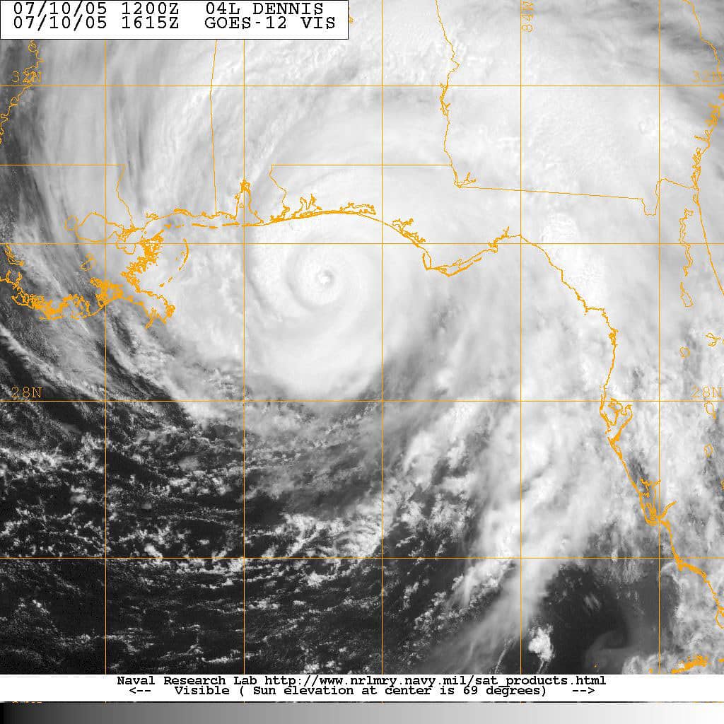
Florida's hurricane climatology makes El Niño years notably calmer for the state on average. Historical data show that Florida landfalling hurricanes occur less frequently during El Niño years than during La Niña or neutral conditions, though prominent exceptions exist. Hurricane Andrew struck South Florida as a Category 5 storm in 1992 during a moderate El Niño year, demonstrating that the statistical suppression of El Niño cannot be treated as a guarantee of safety for any specific coastal community. Emergency managers consistently cite Andrew as a reminder that seasonal forecasts describe averages, not certainties.
The Wild Card of Warm Atlantic Waters
The primary factor working against a fully suppressed season is the anomalously warm sea-surface temperatures that continue to characterize the North Atlantic and tropical Atlantic regions. Ocean temperatures in the main development region, broadly the band of warm water stretching from the west African coast to the Caribbean, have remained well above the long-term average since 2023. Warm ocean water is the primary energy source for tropical cyclones, and elevated temperatures can allow storms to intensify more rapidly than historical averages would predict.
The National Hurricane Center noted in its May 15 Tropical Weather Outlook, the first routine Atlantic outlook of the 2026 season, that no tropical cyclone formation was expected in the near term. As of May 20, the Atlantic basin remained quiet and no disturbances of concern were being tracked. However, meteorologists caution that early-season tranquility in May tells the public very little about what August and September will bring. Approximately 85 percent of all major Atlantic hurricanes occur during those peak season months.
Florida emergency managers have been tracking ocean temperature data alongside El Niño model runs since early spring. The Florida Division of Emergency Management briefed county emergency directors statewide on the seasonal outlook context in recent weeks, emphasizing that preparation timelines must not be shortened because of a below-normal forecast. The agency's position is consistent across forecasts of all types: residents should treat every hurricane season as a genuine threat requiring active preparation.
Florida's Pre-Season Preparation Status
The Florida Division of Emergency Management has been conducting pre-season readiness exercises, updating public shelter rosters, and reviewing debris removal contracts throughout May in preparation for the June 1 season start. The agency coordinates with county emergency management offices to maintain a network of public hurricane shelters capable of accommodating hundreds of thousands of evacuees, including people with access and functional needs who require additional support services during a disaster response.
Hillsborough, Pinellas, Miami-Dade, Broward, Palm Beach, and Lee counties, all of which have experienced devastating hurricane impacts in the past three decades, completed updates to their Comprehensive Emergency Management Plans this spring. Southwest Florida communities, still carrying institutional memory from Hurricane Ian's catastrophic 2022 storm surge in Lee County, have invested significantly in shelter hardening, communication system improvements, and evacuation route signage since that storm caused roughly $112 billion in damages.
The My Safe Florida Home program, which provides grants to homeowners to strengthen roofs, windows, and doors against hurricane wind damage, has seen high demand through late 2025 and into 2026 as homeowners seek to reduce insurance premium burdens while improving their structures' physical resilience. State officials have emphasized the program as a key tool for reducing storm losses over the long term, regardless of any individual season's forecast activity level.
The Insurance Market Watches the Forecast
Florida's property insurance market, which has been under stress since Hurricane Irma in 2017 and suffered severe strain through subsequent storms and litigation challenges, views each hurricane season forecast as a potential inflection point. Reinsurers, who provide the backstop coverage that allows primary insurance companies to write policies in hurricane-prone states, price their contracts partly based on seasonal outlooks and partly on multi-year catastrophe models.
A below-normal seasonal forecast does not by itself reduce reinsurance costs, since a single major landfall event can generate tens of billions of dollars in insured losses regardless of how quiet the rest of the season proves. However, the shift from two consecutive above-normal seasons to a forecast below-normal year does reduce the statistical frequency of total seasonal activity that reinsurers must account for, providing modest relief to insurers pricing policies for the coming contract year.
Citizens Property Insurance Corporation, Florida's state-backed insurer of last resort, which still holds policies on more than one million Florida properties despite its ongoing depopulation effort, is required to purchase reinsurance in the private market to cover its maximum probable loss exposure. Citizens' reinsurance procurement for 2026 has been finalized in recent weeks, and market observers suggested the below-normal outlook may have supported slightly more favorable pricing than the two prior years of above-normal forecasts allowed.
Historical Context for Below-Normal Seasons
Below-normal hurricane seasons have not historically been benign for Florida. The 1992 season, classified as below-normal overall, produced Andrew, which at the time was the most destructive natural disaster in United States history. The 2004 season, which brought four Florida landfalls in Charley, Frances, Ivan, and Jeanne across a six-week stretch, was not a record-setting season by raw storm counts but produced generational destruction across much of the state.
Emergency managers and meteorologists consistently cite 2004 as a reminder that seasonal forecasts must never be interpreted as predictions about any individual storm's behavior or track. Four separate major storms affecting Florida in a single season remains one of the most extraordinary runs in the modern record and fundamentally changed the state's approach to hurricane preparedness, triggering decades of investment in shelter capacity, evacuation route improvements, and insurance market reform.
The lesson that emergency professionals emphasize each spring is consistent: residents should not let a quieter forecast induce complacency. The Saffir-Simpson wind scale, the five-category system used to describe hurricane intensity, does not fully capture the threat from storm surge, inland flooding, or rainfall, which are often the most lethal components of a landfalling hurricane regardless of category designation. A Category 1 storm making landfall at high tide over a low-lying coastal community can produce life-threatening inundation that a Category 3 making landfall at a different angle and tide cycle might not.
What Floridians Should Do Before June 1
State and county emergency managers are asking all Floridians to complete basic preparedness steps before the June 1 start of hurricane season. The recommended preparation checklist includes assembling or refreshing a household disaster supply kit with at least 72 hours of water, food, medications, and copies of important documents; identifying each household's evacuation zone through the Florida Division of Emergency Management's Know Your Zone program; and confirming that flood insurance policies are active, current, and sufficient for the property's risk level.
Standard homeowners insurance policies in Florida do not cover flood damage, and National Flood Insurance Program policies carry a 30-day waiting period before they take effect. Floridians who purchase or renew flood insurance before the end of May will have coverage in place when the season opens, but those who wait until a storm is approaching the coast will find no flood coverage available for that event under standard policy terms. This gap in coverage has resulted in significant uninsured losses for Florida homeowners in multiple recent storms.
The NOAA Aircraft Operations Center in Lakeland, where Thursday's announcement was made, is home to the WP-3D Orion and Gulfstream IV aircraft that fly directly into Atlantic hurricanes to gather real-time weather data. Those measurements feed directly into the forecast models used by the National Hurricane Center in Miami to predict a storm's intensity, size, and track. Florida's role as home base for hurricane hunter operations, as well as the location of the National Hurricane Center in Miami-Dade County, reflects the state's central position in the federal hurricane forecasting and response infrastructure. The 2026 Atlantic hurricane season begins in 11 days.
Spotted an issue with this article?
Have something to say about this story?
Write a letter to the editor